PERI-CENE FRAMEWORK
(20 questions on peri-urbanization, climate change, vulnerability, governance and synergistic pathways)
(this is an early version with details to follow )
Peri-Urban
POTENTIAL THEMES & TOPICS
OVERVIEW
Spatial patterns
- Urban direct expansion
- Urban / rural fringe & gradient
- Counter-urbanization effect
- Urban agglomeration effect
Maps & Indicators
Functional dynamics
- Population growth & housing
- Technology & infrastructure
- Economy & employment
- Real estate & markets
Maps & Indicators
Social-eco dynamics
- Social demographics & lifestyle
- Environment & resources
- Policy & governance
- Culture & ethics
Maps & Indicators
Global-local dynamics
- Internal structures
- external interactions
- power dynamics
- challenges & conflicts
Maps & Indicators
Climate Risk
POTENTIAL THEMES & TOPICS
OVERVIEW
Climate change direct effects
- temperature
- precipitation, storm etc
- coastal effects
Maps & Indicators
Climate direct hazards & impacts
- wildfire, heatwave, drought,
- flood, storm, cyclone
- landslide, sea incursion etc,
Maps & Indicators
Indirect hazards & nexus effects
- water resources
- farming & forestry
- energy & resources
- ecosystems & microclimates
- critical infrastructure
Maps & Indicators
Peri-urban impacts on climate
- CO2 emissions from energy
- GHG emissions from land-use
- Land-use & forestry change
- Carbon storage
Maps & Indicators
Vulnerability
POTENTIAL THEMES & TOPICS
OVERVIEW
Physical sensitivity & capacity
- Soil & vegetation
- Topography & stability
- Settlement form & structure
Maps & Indicators
Techno-economic capacity
- technical & infrastructure
- Markets & value effects
- Employment & livelihoods
Maps & Indicators
Eco-social-cultural capacity
- Affluence / deprivation
- Education / communication
- Cultural issues
Maps & Indicators
Governance adaptive capacity
- Local government
- Public services & infrastructure
- Emergency services
- Civil & community
Maps & Indicators
Governance
POTENTIAL THEMES & TOPICS
OVERVIEW
Adaptive governance & institutions
- Public Sector
- Private Sector
- Civic Sector
- Citizens etc
Maps & Indicators
Informal governance & livelihood
- Informal land-use, settlements
- Corruption & nepotism
- Social innovation & enterprise
Maps & Indicators
System resilience & intelligence
- Social learning & collaboration
- Social co-creation & mobilization potential
- System transformation potential
Maps & Indicators
Synergistics
POTENTIAL THEMES & TOPICS
OVERVIEW
Systems / syndromes (present baselines)
- Main cross-cutting issues: e.g.
- Airport / port cities:
- Rural livelihoods:
- Informal development
Maps & Indicators
Scenarios (future possibilities)
- Critical themes: (STEEP): e.g.
- Social cohesion declines
- AI / IOT emerges
- Climate change accelerates
Maps & Indicators
Synergies (future ideas, opportunities)
- Potential ideas, connections, opportunities
Maps & Indicators
Strategies (present pathways, actions)
- Goals, objectives, targets for ways forward.
Maps & Indicators
Chennai region overview
Chennai region overview
Heavy-industries complex along ecologically-degraded coastline and scattered towns and farmlands
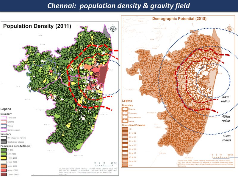
population density & gravity field
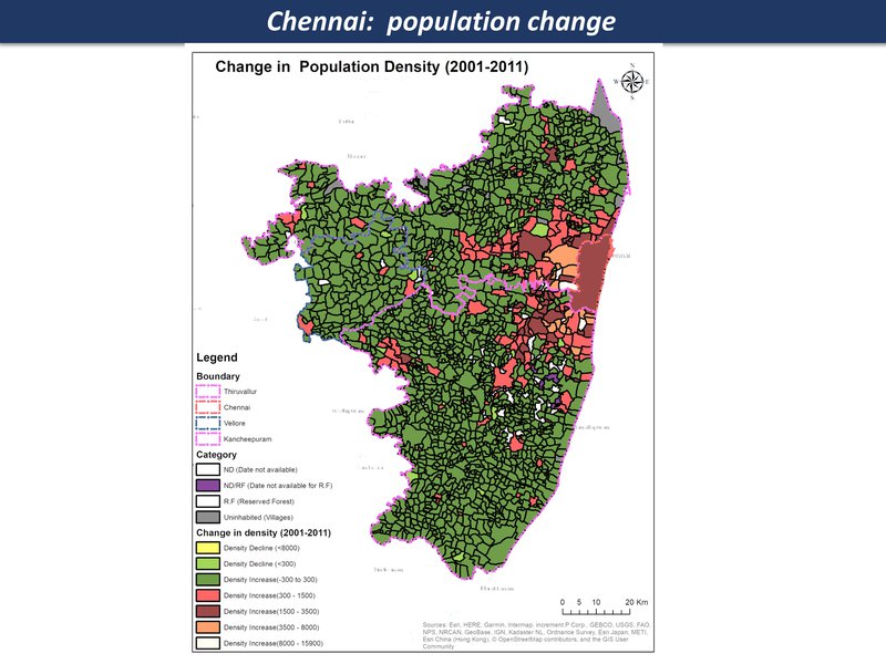
population density change
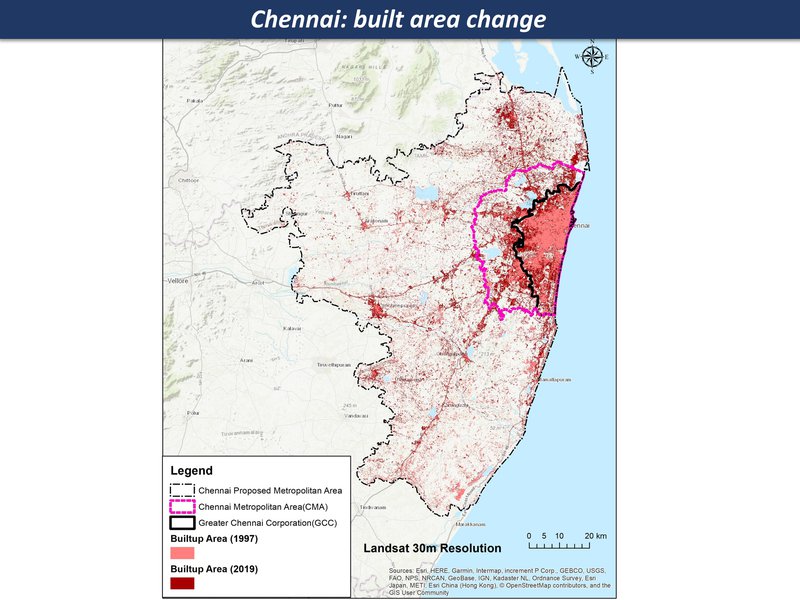
Chennai: built area change
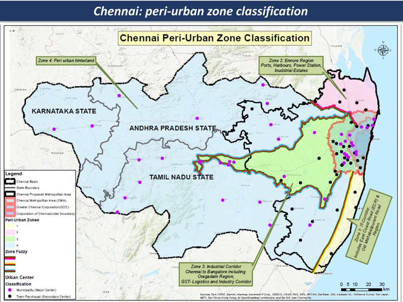
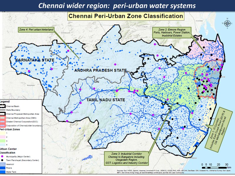
peri-urban zones
Chennai region overview
Chennai region overview
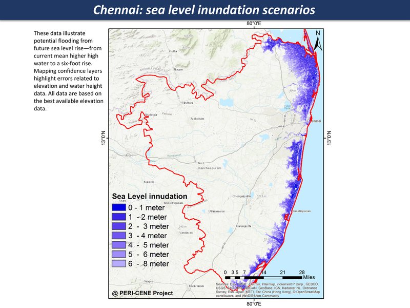
Sea level rise, increase in extreme events - storm, storm surges
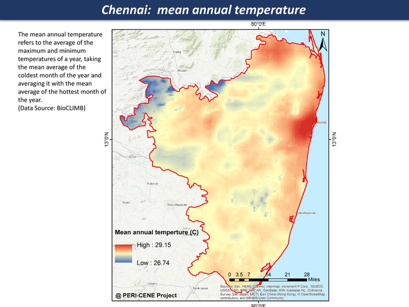
mean annual temperature
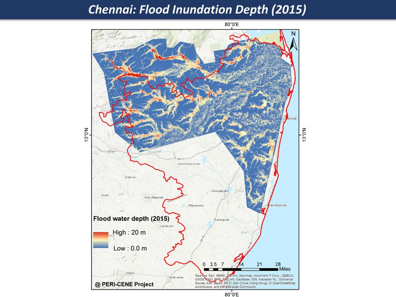
Flood inundation
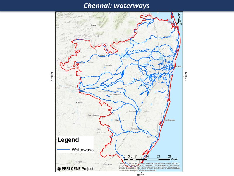
peri-urban water systems
Chennai region overview
Chennai region overview
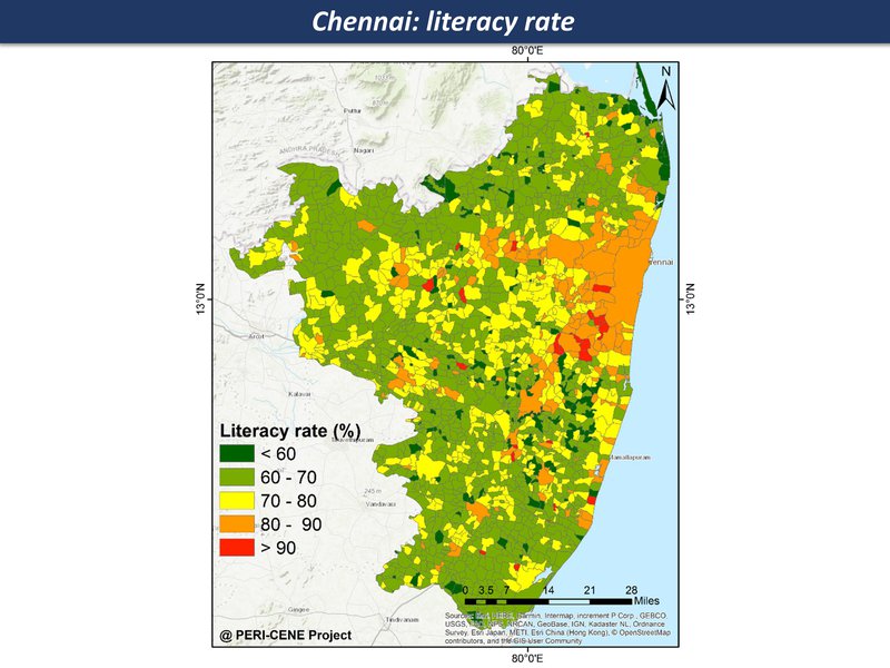
urban eco-social-economic mix in some areas has growing vulnerability
waterways
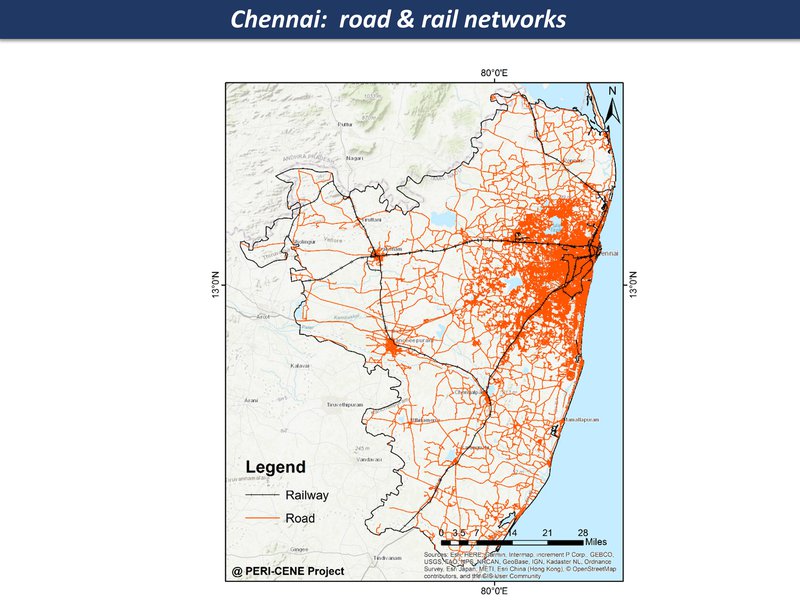
road & rail networks
literacy rate
Chennai region overview
Chennai region overview
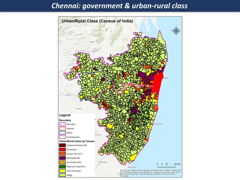
Quasi-government arrangements with industries, limited overview and regulation; mostly panchayat and local governance structures since there are many villages and small towns in this region
government & urban-rural class
Chennai region overview
Chennai region overview
opportunities for transformation - from a disrupted 'anti-eco-city-region' towards a post-industrial eco-region
Zone (d)
Chennai - hinterland
Large watershed area with mid-sized cities, villages and farmlands and small-medium scale industries
Large watershed area with mid-sized cities, villages and farmlands and small-medium scale industries
Zone (d)
Chennai - hinterland
(heat, precipitation and storm: impacts on water systems & agricultural livelihoods)
(heat, precipitation and storm: impacts on water systems & agricultural livelihoods)
Zone (d)
Chennai - hinterland
marginal livelihoods in sensitive landscapes with growing pressure of urbanization
marginal livelihoods in sensitive landscapes with growing pressure of urbanization
Zone (d)
Chennai - hinterland
fragmented local governance & civil society
Zone (d)
Chennai - hinterland
Can a new eco-social order emerge?
Commuter settlement structure increases vulnerability to climate change
social divisions & exclusions multiply up
Synergies of agri-landscape & socio-economic landscape
Integrated adaptive lowland per-urban, with regenerative adaptive agriculture & ecosystems stewardship

