Picture5.png

Chennai

Chennai is India’s fourth largest metropolitan agglomeration with 9 million inhabitants. Founded in 1640, and a major centre of the British empire, its growth has been phenomenal only since around 1990. While the city-region operates roughly in accordance to a master plan, governance outside city corporation limits is subject to many forms and levels of authority.

As in many other regions, entities make various territorial claims ‘beyond the plan’, which are identified with slums or other informal arrangements, that may concurrently be ‘illegal’ but sanctioned by the government. Chennai has a coastal tropical dry forest ecology, and intermittently faces the challenges of water scarcity and flooding, intensifying with peri-urbanisation and climate change. Water management through an elaborate system of connected tanks and stream channels has been a significant part of the history of the Tamil Nadu lowland and the neighboring Deccan plateau in Karnataka and Andhra Pradesh since the 11th century.

In the course of a series of interventions around urban water supply, construction and changes in agriculture, this complex socio-technical system has changed significantly, increasing the vulnerability of the city-region and its hinterland, which in 2015 resulted in widespread flooding.

.

.


Chennai region

Peri-urban types & zones

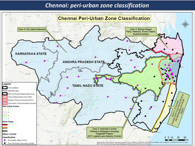
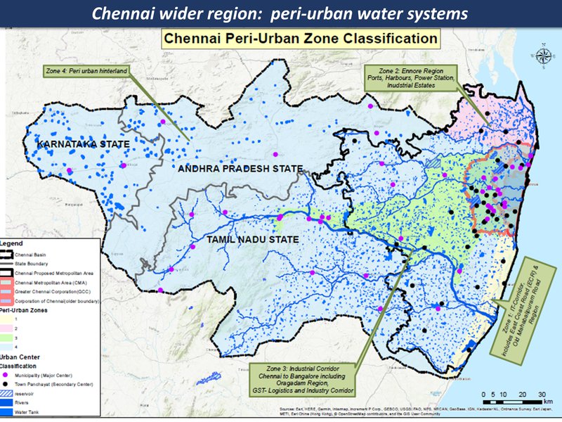
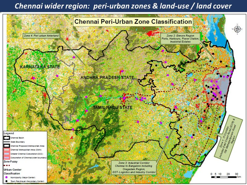
The peri-urban around Chennai is mapped here in four main zones, as on the following pages:

(A) Ennore & Thiruvallur

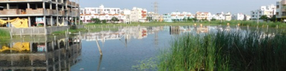
to the north of Chennai is a heavy-industries complex along the ecologically-degraded coastline, amid scattered towns and farmlands. The threats are from multiple climate change pressures, intersecting with a complex and problematic urban expansion. The opportunities are for a transition - from an eco-urban chaos to a post-industrial eco-region...

(B) Industrial corridor

includes the expansion of the metropolitan area in the direction of Bangalore. The landscape is one of major highways criss-crossing industrial hubs, and gated communities interspersed with local villages and farmlands, and the ancient system of water bodies now at risk.

(C) I.T. corridor

This area covers the southern coastal-to-hinterland landscape, with hi-tech industrial and entertainment / scenic / tourist corridors, interspersed with fishing villages, salt pans and small-scale farming

(D) Hinterland

The Chennai hinterland area includes a large watershed, with mid-sized cities, villages and farmlands and small-medium scale industries. (This area overlaps 3 states: Tamil Nadu, Karnataka and Andhra Pradesh)

.

.


Chennai region - zones & LULC.jpg

.

.


Overview of peri-urbanization and climate risks / adaptation

The Chennai case is large and complex.... here we show the summary of the Peri-cene Framework to illustrate the differences between the four zones. The following pages have more detail on each of the '20 questions' in the Framework.


Chennai region overview of zones

Peri-Urban
Climate Risk
Vulnerability
Governance
Synergistics
Chennai - Ennore
Heavy-industries complex along ecologically-degraded coastline and scattered towns and farmlands
Sea level rise, increase in extreme events - storm, storm surges
urban eco-social-economic mix in some areas has growing vulnerability
Quasi-government arrangements with industries, limited overview and regulation;
from the world's first industrial city-region to the first post-industrial eco-region
Chennai - Industrial corridor
Major highways criss-crossing industrial hubs and gated communities interspersed with farmlands and water bodies
Extreme rainfall events triggering floods and droughts and subsequent impacts on land, biodiversity
Fringe villages and towns adjacent to water bodies at higher levels of risk from flooding;
pockets of civil society action and local innovation could trigger pathways of transformation
Growing pressure on fragile landscapes & settlements: potential for socio-eco-resilience
Chennai - I.T. corridor
Coastal-to-hinterland landscape with hi-tech industrial and entertainment/scenic corridors, interspersed with fishing villages, salt pans and small-scale farming
High-risk coastal infrastructure, floods, fragmented land/waterscape
Rapid urbanisation leading to fragmented landscapes coastal infrastructure risk and loss of livelihoods
fragmented local governance, complex
potential new forms of eco-urban form & design, in new forms of community
Chennai - hinterland
Large watershed area with mid-sized cities, villages and farmlands and small-medium scale industries
(heat, precipitation and storm: impacts on water systems & agricultural livelihoods)
marginal livelihoods in sensitive landscapes with growing pressure of urbanization
fragmented local governance & civil society
Can a new eco-social order emerge?

Overview with spatial analysis

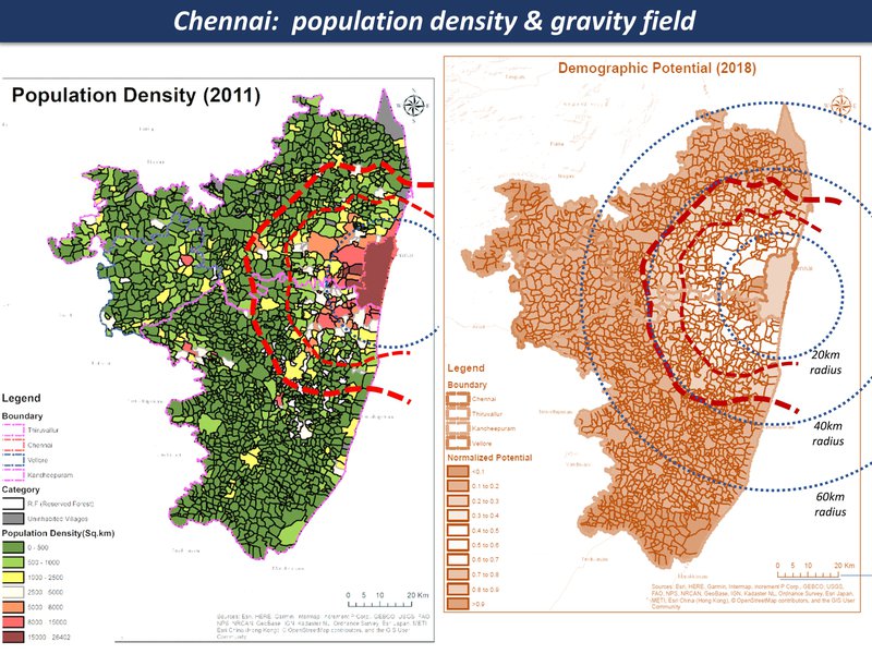
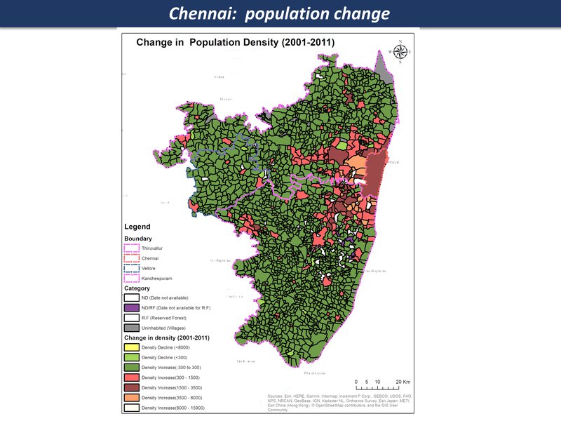
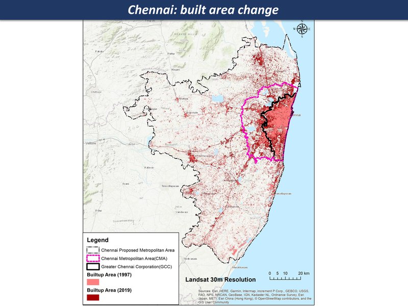
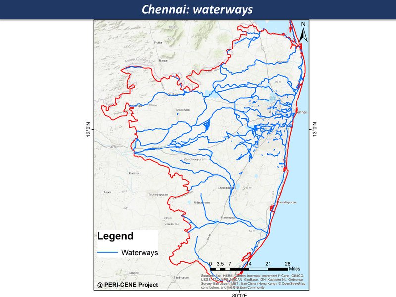
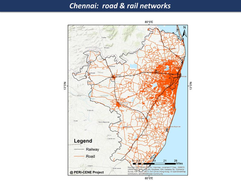
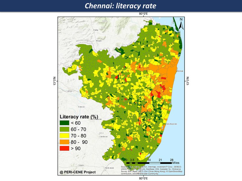
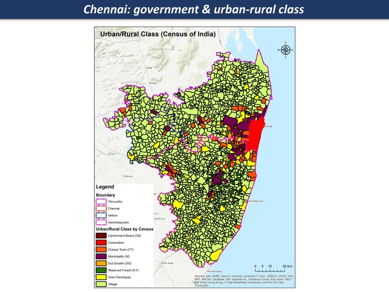
While the maps can't tell us everything about a large and complex system, they are a good place to start a discussion, each one telling a kind of story. Here are the main maps for the Chennai region so far, as a thematic map compilation - a working 'Atlas of the peri-urban' (preliminary work in progress)

Chennai map compilation

.


Peri-Urban

POTENTIAL THEMES & TOPICS
OVERVIEW
Spatial patterns
  • Urban direct expansion
  • Urban / rural fringe & gradient
  • Counter-urbanization effect
  • Urban agglomeration effect
Maps & Indicators
Functional dynamics
  • Population growth & housing
  • Technology & infrastructure
  • Economy & employment
  • Real estate & markets
Maps & Indicators
Social-eco dynamics
  • Social demographics & lifestyle
  • Environment & resources
  • Policy & governance
  • Culture & ethics
Maps & Indicators
Global-local dynamics
  • Internal structures
  • external interactions
  • power dynamics
  • challenges & conflicts
Maps & Indicators

Climate Risk

POTENTIAL THEMES & TOPICS
OVERVIEW
Climate change direct effects
  • temperature
  • precipitation, storm etc
  • coastal effects
Maps & Indicators
Climate direct hazards & impacts
  • wildfire, heatwave, drought,
  • flood, storm, cyclone
  • landslide, sea incursion etc,
Maps & Indicators
Indirect hazards & nexus effects
  • water resources
  • farming & forestry
  • energy & resources
  • ecosystems & microclimates
  • critical infrastructure
Maps & Indicators
Peri-urban impacts on climate
  • CO2 emissions from energy
  • GHG emissions from land-use
  • Land-use & forestry change
  • Carbon storage
Maps & Indicators

Vulnerability

POTENTIAL THEMES & TOPICS
OVERVIEW
Physical sensitivity & capacity
  • Soil & vegetation
  • Topography & stability
  • Settlement form & structure
Maps & Indicators
Techno-economic capacity
  • technical & infrastructure
  • Markets & value effects
  • Employment & livelihoods
Maps & Indicators
Eco-social-cultural capacity
  • Affluence / deprivation
  • Education / communication
  • Cultural issues
Maps & Indicators
Governance adaptive capacity
  • Local government
  • Public services & infrastructure
  • Emergency services
  • Civil & community
Maps & Indicators

Governance

POTENTIAL THEMES & TOPICS
OVERVIEW
Adaptive governance & institutions
  • Public Sector
  • Private Sector
  • Civic Sector
  • Citizens etc
Maps & Indicators
Informal governance & livelihood
  • Informal land-use, settlements
  • Corruption & nepotism
  • Social innovation & enterprise
Maps & Indicators
System resilience & intelligence
  • Social learning & collaboration
  • Social co-creation & mobilization potential
  • System transformation potential
Maps & Indicators

Synergistics

POTENTIAL THEMES & TOPICS
OVERVIEW
Systems / syndromes (present baselines)
  • Main cross-cutting issues: e.g.
  • Airport / port cities:
  • Rural livelihoods:
  • Informal development
Maps & Indicators
Scenarios (future possibilities)
  • Critical themes: (STEEP): e.g.
  • Social cohesion declines
  • AI / IOT emerges
  • Climate change accelerates
Maps & Indicators
Synergies (future ideas, opportunities)
  • Potential ideas, connections, opportunities
Maps & Indicators
Strategies (present pathways, actions)
  • Goals, objectives, targets for ways forward.
Maps & Indicators
Chennai region overview
Heavy-industries complex along ecologically-degraded coastline and scattered towns and farmlands
population density & gravity field
population density change
Chennai: built area change
peri-urban zones
Chennai region overview
Sea level rise, increase in extreme events - storm, storm surges
mean annual temperature
Flood inundation
peri-urban water systems
Chennai region overview
urban eco-social-economic mix in some areas has growing vulnerability
waterways
road & rail networks
literacy rate
Chennai region overview
Quasi-government arrangements with industries, limited overview and regulation; mostly panchayat and local governance structures since there are many villages and small towns in this region
government & urban-rural class
Chennai region overview
opportunities for transformation - from a disrupted 'anti-eco-city-region' towards a post-industrial eco-region

Return to article index