PERI-CENE FRAMEWORK
(20 questions on peri-urbanization, climate change, vulnerability, governance and synergistic pathways)
.
.
Peri-Urban
POTENTIAL THEMES & TOPICS
OVERVIEW
Spatial patterns
- Urban direct expansion
- Urban / rural fringe & gradient
- Counter-urbanization effect
- Urban agglomeration effect
Maps & Indicators
Functional dynamics
- Population growth & housing
- Technology & infrastructure
- Economy & employment
- Real estate & markets
Maps & Indicators
Social-eco dynamics
- Social demographics & lifestyle
- Environment & resources
- Policy & governance
- Culture & ethics
Maps & Indicators
Global-local dynamics
- Internal structures
- external interactions
- power dynamics
- challenges & conflicts
Maps & Indicators
Climate Risk
POTENTIAL THEMES & TOPICS
OVERVIEW
Climate change direct effects
- temperature
- precipitation, storm etc
- coastal effects
Maps & Indicators
Climate direct hazards & impacts
- wildfire, heatwave, drought,
- flood, storm, cyclone
- landslide, sea incursion etc,
Maps & Indicators
Indirect hazards & nexus effects
- water resources
- farming & forestry
- energy & resources
- ecosystems & microclimates
- critical infrastructure
Maps & Indicators
Peri-urban impacts on climate
- CO2 emissions from energy
- GHG emissions from land-use
- Land-use & forestry change
- Carbon storage
Maps & Indicators
Vulnerability
POTENTIAL THEMES & TOPICS
OVERVIEW
Physical sensitivity & capacity
- Soil & vegetation
- Topography & stability
- Settlement form & structure
Maps & Indicators
Techno-economic capacity
- technical & infrastructure
- Markets & value effects
- Employment & livelihoods
Maps & Indicators
Eco-social-cultural capacity
- Affluence / deprivation
- Education / communication
- Cultural issues
Maps & Indicators
Governance adaptive capacity
- Local government
- Public services & infrastructure
- Emergency services
- Civil & community
Maps & Indicators
Governance
POTENTIAL THEMES & TOPICS
OVERVIEW
Adaptive governance & institutions
- Public Sector
- Private Sector
- Civic Sector
- Citizens etc
Maps & Indicators
Informal governance & livelihood
- Informal land-use, settlements
- Corruption & nepotism
- Social innovation & enterprise
Maps & Indicators
System resilience & intelligence
- Social learning & collaboration
- Social co-creation & mobilization potential
- System transformation potential
Maps & Indicators
Synergistics
POTENTIAL THEMES & TOPICS
OVERVIEW
Systems / syndromes (present baselines)
- Main cross-cutting issues: e.g.
- Airport / port cities:
- Rural livelihoods:
- Informal development
Maps & Indicators
Scenarios (future possibilities)
- Critical themes: (STEEP): e.g.
- Social cohesion declines
- AI / IOT emerges
- Climate change accelerates
Maps & Indicators
Synergies (future ideas, opportunities)
- Potential ideas, connections, opportunities
Maps & Indicators
Strategies (present pathways, actions)
- Goals, objectives, targets for ways forward.
Maps & Indicators
Chennai region overview
Chennai region overview
Heavy-industries complex along ecologically-degraded coastline and scattered towns and farmlands
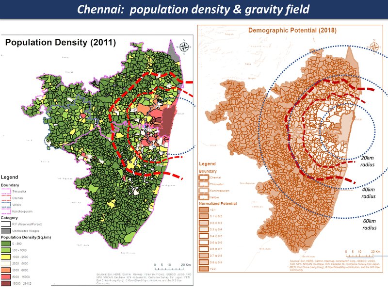
population density & gravity field
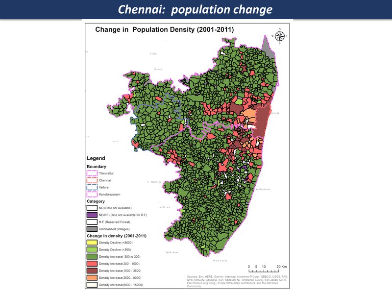
population density change
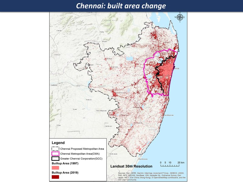
Chennai: built area change
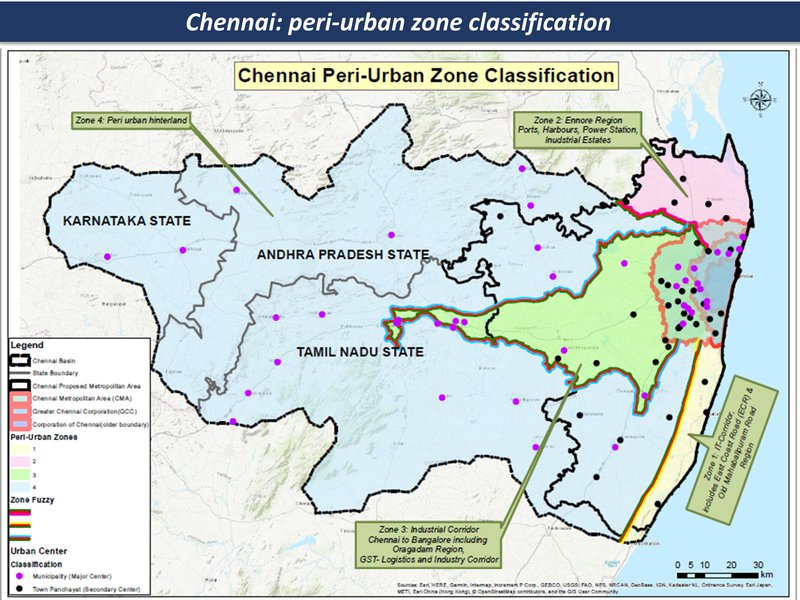
peri-urban zones
Chennai region overview
Chennai region overview
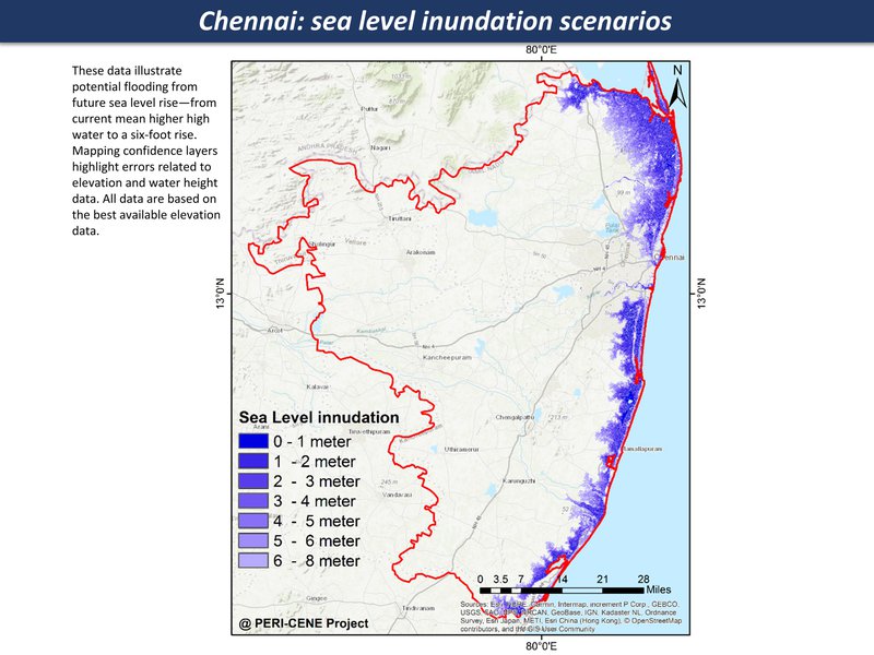
Sea level rise, increase in extreme events - storm, storm surges
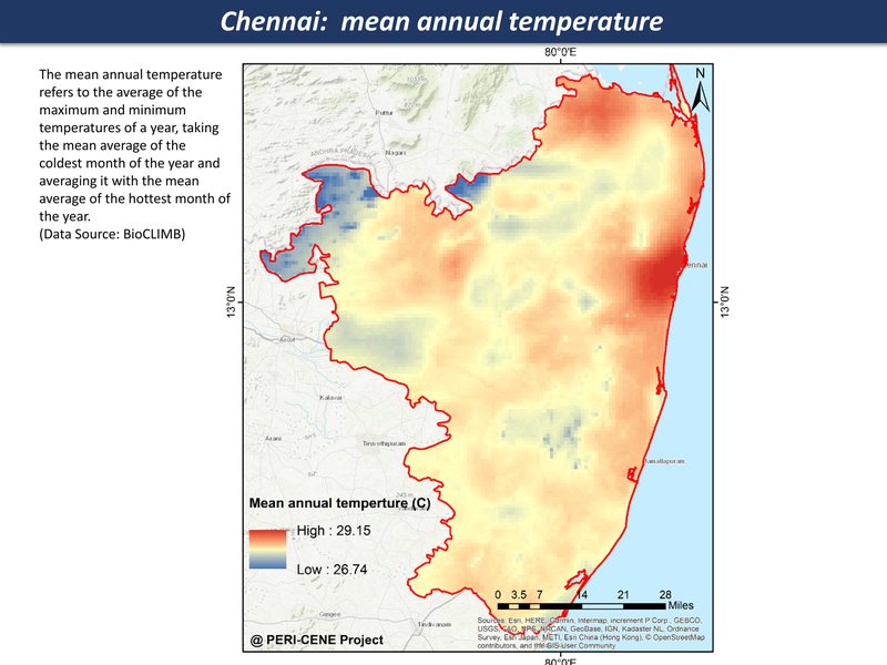
mean annual temperature
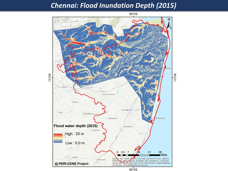
Flood inundation
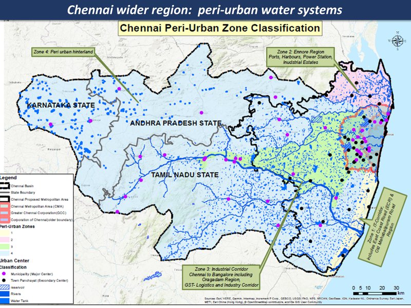
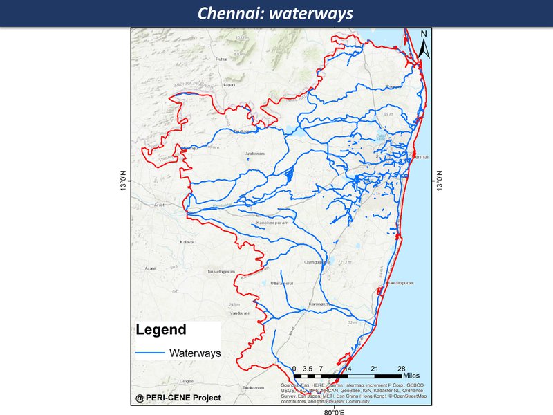
peri-urban water systems
Chennai region overview
Chennai region overview
urban eco-social-economic mix in some areas has growing vulnerability
waterways
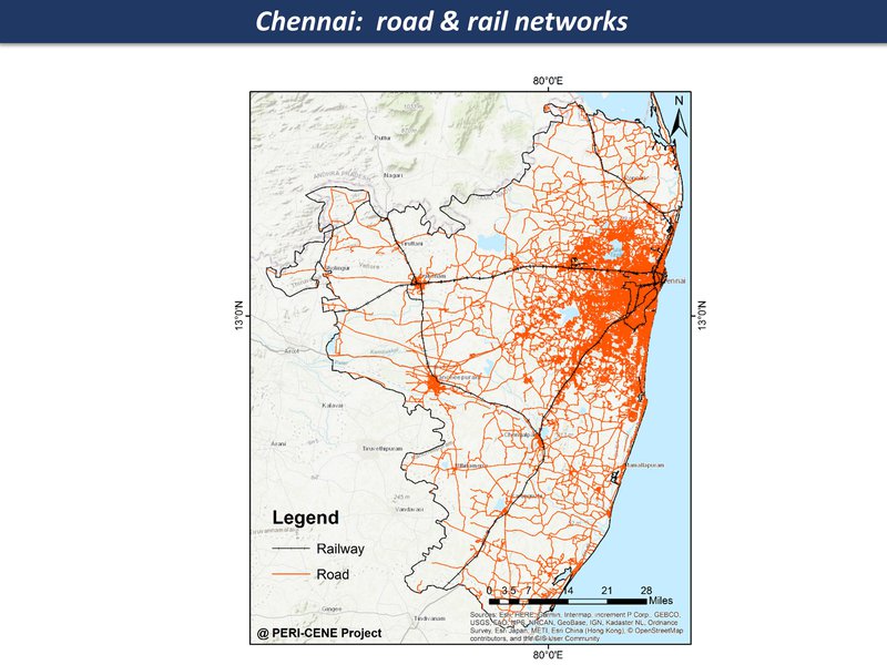
road & rail networks
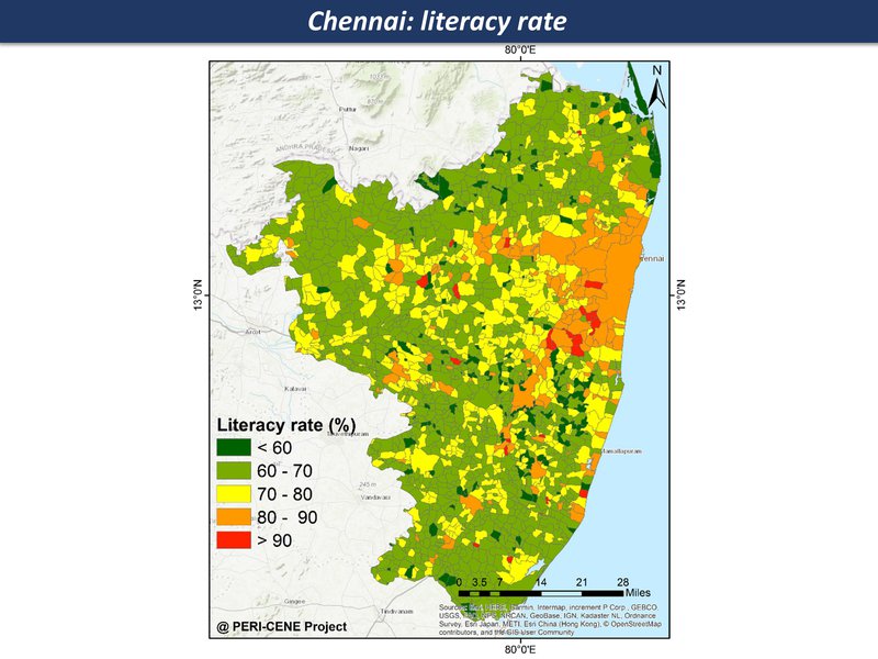
literacy rate
Chennai region overview
Chennai region overview
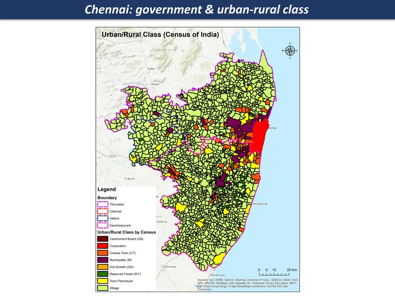
Quasi-government arrangements with industries, limited overview and regulation; mostly panchayat and local governance structures since there are many villages and small towns in this region
government & urban-rural class
Chennai region overview
Chennai region overview
opportunities for transformation - from a disrupted 'anti-eco-city-region' towards a post-industrial eco-region
Zone (c)
Chennai - I.T. corridor
Coastal-to-hinterland landscape with hi-tech industrial and entertainment/scenic corridors, interspersed with fishing villages, salt pans and small-scale farming
Hi-tech hubs and gated communities and villas interspersed with fishing villages, farms and waterbodies with two major roads running through
Upscale gated communities, beach homes, amusement parks juxtaposed with small coastal fishing villages transitioning into a post-industrial economy — IT hubs, electronics and information services alongside traditional livelihoods - fishing, salt pan work and recent hobby cultures - eg: horticulture gardens: Mid-to-high population growth, speculative real estate development, hostels for IT workers, slum resettlement colonies and social housing schemes, fishing hamlets
Middle and upper-middle class lifestyles interspersed with large-scale slum resettlement complexes : with complex ecologies - backwater lagoons, marshes and wetlands; loss of casuarina groves and wetlands. Fragmented enclaves, modern aspirations,
The IT Corridor was developed as a high-investment corridor, “future of the city”, ECR transitions from weekend getaway to attracting high-end residential real estate; Lots of global traffic owing to IT and electronics investments, expat communities; multiple ecosystems at risk from surge in populations in the past 2 decades
Zone (c)
Chennai - I.T. corridor
High-risk coastal infrastructure, floods, fragmented land/waterscape
Extreme rainfall events, drought, sea level rise
degraded water bodies leading to floods.waterlogging, gradual sea level rise and storm surge-risk
degraded ecologies, polluted water bodies and channels, coastal risks — impacts on indigenous livelihoods
Zone (c)
Chennai - I.T. corridor
Rapid urbanisation leading to fragmented landscapes coastal infrastructure risk and loss of livelihoods
Low-lying brackish water and freshwater bodies, dry tropical scrub, mixed land-use
Speculative developments leading to encroached water bodies and wetlands
fragmented local governance, complex
Zone (c)
Chennai - I.T. corridor
fragmented local governance, complex
Challenges constitute regulating and provision of basic services like sewage disposal and clean drinking water as it contains zones which are amongst the last few added to Chennai municipal boundaries; created pockets of large slum resettlement housing amidst gated communities and hostel dwellings
Rise of new-age farmers, restaurants with locally-grown food, small-scale horticulture and hobby gardening centres creating niche clienteles and simultaneously new imaginations around environmental awareness and conservation - mostly individuals or small citizen groups
large tracts of land on lease to individuals which have been rented out to tenants, farmers, salt pans etc. SEZ’s have separate arrangements with firms that have set up offices within these planned areas
potential for new-age farmers and environmentally-conscious to create pockets of resilience if they work together; small fishing hamlets and farming communities possess varying levels of social capital
Zone (c)
Chennai - I.T. corridor
potential new forms of eco-urban form & design, in new forms of community
rapid-growth corridor/IT/electronics/service economy
impacts of climate change felt across the landscape, further breakdown of social cohesion, isolated communities
synergies of alternative eco-socio-economic models - tourism, nature trails, small agricultural cooperatives, revival of local ecologies
regional/landcape planning and monitoring bodies, local resilience enhanced through ecosystems stewardship and smalls-scale economies