Manchester region: summary table
Peri-Urban
Climate Risk
Vulnerability
Governance
Synergistics
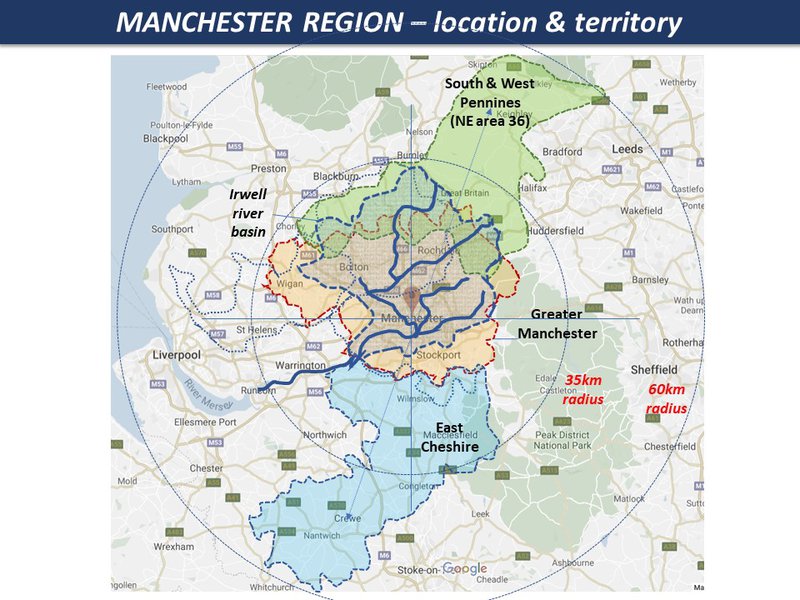
Manchester Region
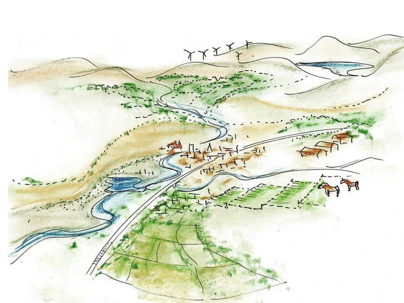
conurbation of 3 million with hills to north & east, plains to south & west
generally moderate climate risk, but growing risks and uncertainties for the future
urban eco-social-economic mix in some areas has growing vulnerability
Local administrative boundaries do not reflect peri-urban reality. There is no regional authority for coordination. In the background is a general alienation from under-funded local government:
potential pathways - from the world's first industrial city-region to the first post-industrial eco-region
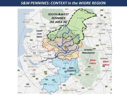
South & West Pennines
Upland landscape with former industrial valley development
Fluvial flood, wildfire, heat & drought, soil erosion, landscape
Landscape sensitivity & marginal livelihoods
Fragmentation of governance: self-help tradition & eco-social innovation
Growing pressure on fragile landscapes & settlements: potential for socio-eco-resilience
Peri-Urban
POTENTIAL THEMES & TOPICS
OVERVIEW
Spatial patterns
- Urban direct expansion
- Urban / rural fringe & gradient
- Counter-urbanization effect
- Urban agglomeration effect
Maps & Indicators
Functional dynamics
- Population growth & housing
- Technology & infrastructure
- Economy & employment
- Real estate & markets
Maps & Indicators
Social-eco dynamics
- Social demographics & lifestyle
- Environment & resources
- Policy & governance
- Culture & ethics
Maps & Indicators
Global-local dynamics
- Internal structures
- external interactions
- power dynamics
- challenges & conflicts
Maps & Indicators
Climate Risk
POTENTIAL THEMES & TOPICS
OVERVIEW
Climate change direct effects
- temperature
- precipitation, storm etc
- coastal effects
Maps & Indicators
Climate direct hazards & impacts
- wildfire, heatwave, drought,
- flood, storm, cyclone
- landslide, sea incursion etc,
Maps & Indicators
Indirect hazards & nexus effects
- water resources
- farming & forestry
- energy & resources
- ecosystems & microclimates
- critical infrastructure
Maps & Indicators
Peri-urban impacts on climate
- CO2 emissions from energy
- GHG emissions from land-use
- Land-use & forestry change
- Carbon storage
Maps & Indicators
Vulnerability
POTENTIAL THEMES & TOPICS
OVERVIEW
Physical sensitivity & capacity
- Soil & vegetation
- Topography & stability
- Settlement form & structure
Maps & Indicators
Techno-economic capacity
- technical & infrastructure
- Markets & value effects
- Employment & livelihoods
Maps & Indicators
Eco-social-cultural capacity
- Affluence / deprivation
- Education / communication
- Cultural issues
Maps & Indicators
Governance adaptive capacity
- Local government
- Public services & infrastructure
- Emergency services
- Civil & community
Maps & Indicators
Governance
POTENTIAL THEMES & TOPICS
OVERVIEW
Adaptive governance & institutions
- Public Sector
- Private Sector
- Civic Sector
- Citizens etc
Maps & Indicators
Informal governance & livelihood
- Informal land-use, settlements
- Corruption & nepotism
- Social innovation & enterprise
Maps & Indicators
System resilience & intelligence
- Social learning & collaboration
- Social co-creation & mobilization potential
- System transformation potential
Maps & Indicators
Synergistics
POTENTIAL THEMES & TOPICS
OVERVIEW
Systems / syndromes (present baselines)
- Main cross-cutting issues: e.g.
- Airport / port cities:
- Rural livelihoods:
- Informal development
Maps & Indicators
Scenarios (future possibilities)
- Critical themes: (STEEP): e.g.
- Social cohesion declines
- AI / IOT emerges
- Climate change accelerates
Maps & Indicators
Synergies (future ideas, opportunities)
- Potential ideas, connections, opportunities
Maps & Indicators
Strategies (present pathways, actions)
- Goals, objectives, targets for ways forward.
Maps & Indicators
Whole city-region with hinterland
Manchester Region
conurbation of 3 million with hills to north & east, plains to south & west
urban expansion
hollowing of inner urban areas, slow suburban expansion
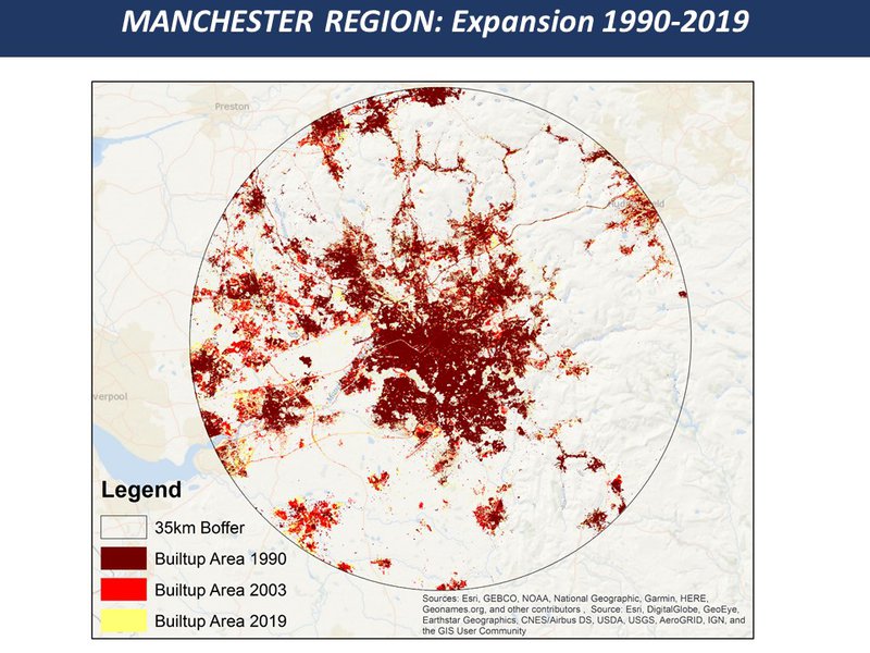
gentrification, social change, precarity in housing
global investment hub around centre, dependency sinks at periphery
Whole city-region with hinterland
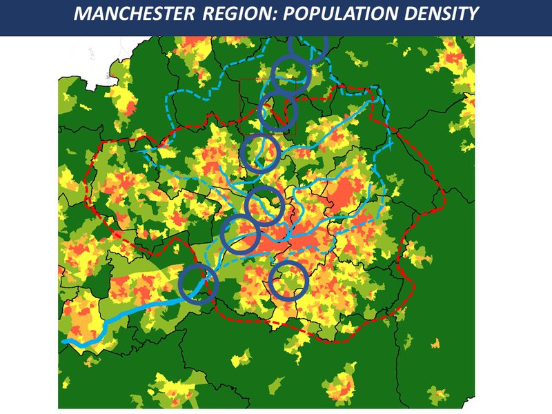
Manchester Region
generally moderate climate risk, but growing risks and uncertainties for the future
Whole city-region with hinterland
Manchester Region
urban eco-social-economic mix in some areas has growing vulnerability
Whole city-region with hinterland
Manchester Region
Local administrative boundaries do not reflect peri-urban reality. There is no regional authority for coordination. In the background is a general alienation from under-funded local government:
Local administrative boundaries do not reflect peri-urban reality. There is no regional authority for coordination. In the background is a general alienation from under-funded local government:
Many social innovations, enterprises and experiments in adaptive governance: public-private partnerships, business-community schemes, grassroots action and democracy of all kinds
Growing awareness of the social economy, solidarity (mutual) economy, and foundational economy, all contributing to the 'real' livelihood of the population, especially the majority not in formal employment
system resilience can be identified in times of crisis e.g. in the 1980s industrial manufacturing was halved with severe destruction of communities and livelihoods.
Whole city-region with hinterland
Manchester Region
potential pathways - from the world's first industrial city-region to the first post-industrial eco-region
scenarios for GM were explored on www.gm2040.com
to be explored with stakeholders
to be explored with stakeholders
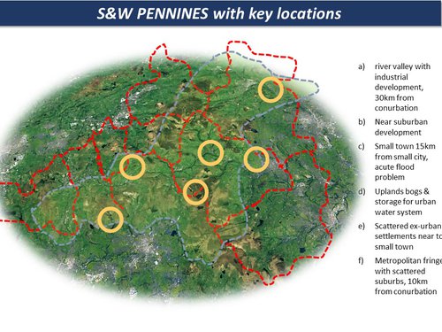
Zone A
South & West Pennines
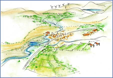
Upland landscape with former industrial valley development
Geographical type: small-medium industrial towns in river valleys, scattered upland villages & small farm settlements
post-industrial economy in transition, to niche production, semi-retired livelihoods, hobby farming etc.
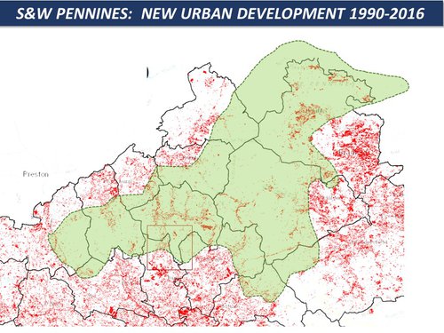
Middle class in-migration & eco-gentrification: decline of family farming: enclaves of deprivation & post-industrial traumas
S.Pennines covers parts of 13 municipalities, provides headwaters & retention capacity: It provides visitor & ecosystem services for 3 city-regions, but on the outer fringe of the urban agenda
Zone A
South & West Pennines
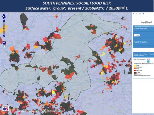
Fluvial flood, wildfire, heat & drought, soil erosion, landscape
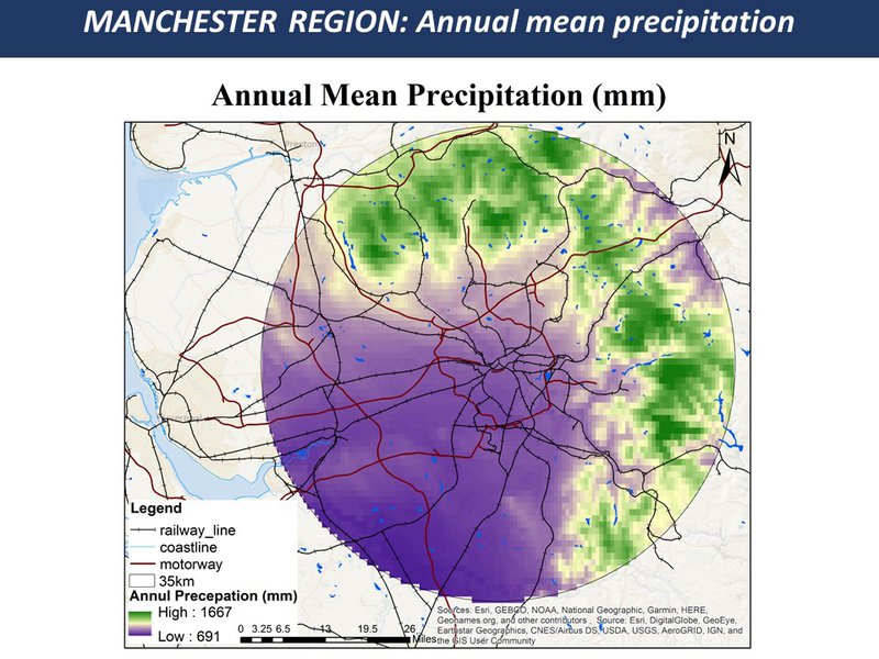
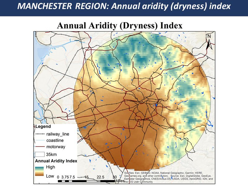
Summer drought & storm: winter precipitation & storm.
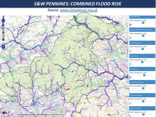
fluvial & flash flooding, upland & valley soil erosion, summer wildfire: progressive landscape change
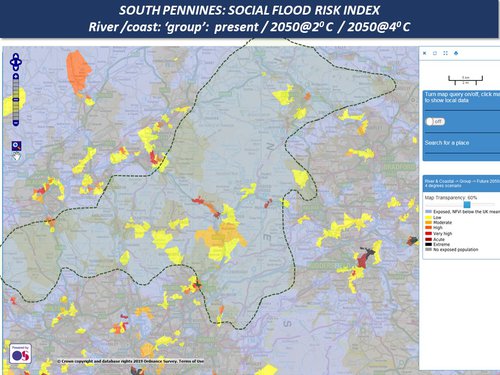
impacts on vulnerable landscape: ecosystems destruction, soil loss, air pollution, climate emissions. Upland farming is already marginal and may become more so.
Loss of peat bog carbon storage & vegetation: loss of (some) ancient woodlands. Transport CO2 is high due to location & geography
Zone A
South & West Pennines
Landscape sensitivity & marginal livelihoods
Upland peat bog with rapid run-off: upland semi-wild vegetation, thin & acidic soils. Most valley bottoms are in flood risk zone 3.
privatized land management increases run-off & flood risk: much low cost housing remains in high risk areas
River valleys magnify flood risk:, polarization of local residents vs incomers who tend to live on higher ground:
fragmented & shrinking local governance: community under change & stress. Privatized infrastructure, fragmented governance
Zone A
South & West Pennines
Fragmentation of governance: self-help tradition & eco-social innovation
Main regulation is for containment of urbanization under housing pressure: the area is on the fringe of 13 municipalities
From local history of cooperatives etc, there are many examples of networks, eco-innovations, social innovations, partnerships etc.
Tradition of social enterprise, self-help, creative action. Landowning is centralized, majority are excluded, most farmers are tenants.
Enhanced social resilience with small town effect, with many synergistic enterprises / networks: however there are class & cultural divides.
Zone A
South & West Pennines
Growing pressure on fragile landscapes & settlements: potential for socio-eco-resilience
Private land management increases: flood risk increases in river valleys: Urban dependency increases:
Climate change accelerates: collapse of upland ecosystems & farming: settlements in valleys become uninhabitable: social divides increase
Synergies of ecosystems & social systems: new semi-rural livelihoods: digital solution to fringe location
integrated adaptive upland landscapes: agro-forestry & eco-social innovation: innovative urban / building design for unstable & high risk locations