Dhaka region: location
Dhaka Region
(The map here shows circles of 20, 40 & 60km radius, a rough approximation to the gravity field).
Dhaka region: overview
Dhaka, the capital and largest city of Bangladesh, is the ninth largest city in the world. A population of 8.9 million residents live in the city limits, and over 21 million reside within the Greater Dhaka Area.
Dhaka is the financial, commercial, and entertainment capital of Bangladesh, accounting for up to 35% of Bangladesh's economy.
The city is divided into 130 wards and 725 mohallas (districts).
Dhaka is an expanding megacity with a problematic peri-urbanization, in the most climate-challenged of any major location: however the adaptive pathways can build on decades of societal learning on ‘living with water’.
Peri-urban: rapid urban & industrial sprawl into densely populated hinterland, in low-lying landscape with complex water systems: general disruption of ecosystems & livelihoods: major development in high risk locations:
Climate change: riverine & flash flooding: major cyclones: indirect sea level rise & incursion: upstream forest depletion, disruption to soil & ecosystems, displacement of floodwater: increasing extreme wet heat days: urban heat island & air pollution:
Societal issues: large scale rural-urban migration, with regional & ethnic displacements: rapid social change & gentrification: disruption to rural livelihoods & farming systems:
Governance: widespread political instability & fragmentation, elite capture, illegal construction & encroachment: widespread climate awareness & policy but capacity is lacking:
Adaptive pathways: urban-rural linkages for food, ecosystems, livelihoods: integrated water management & multi-functional land-use: eco-design for large infrastructure:
Adaptive governance: integrated regional climate-wise planning: civil society governance & expertise in ‘living with water’: transformative grassroots initiatives.
Dhaka region: where is the peri-urban?
Scope: The Dhaka functional area has expanded rapidly, as many surrounding cities have merged and spread into a very densely populated peri-urban and peri-rural hinterland. Hence the standard 200km ‘frame’ used here can only show a subset of this unique mega-agglomeration, and the global typology of peri-urban density (50-300 p/km2 ) should be adjusted in further research.
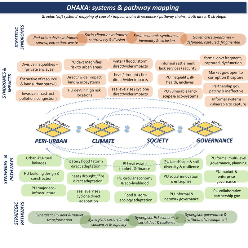
Dhaka region: system mapping
Dhaka region: summary data
Climate Hazard
(World Bank data profile for Dhaka)
Extreme heat - High
Wildfire - High
Water scarcity - Medium
River flood - High
Urban flood - High
Coastal flood - High
Cyclone - High
Tsunami - No data
Landslide - Low
Earthquake - Medium
Volcano - No data
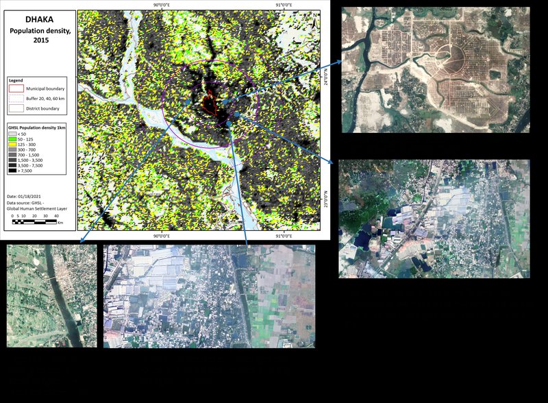
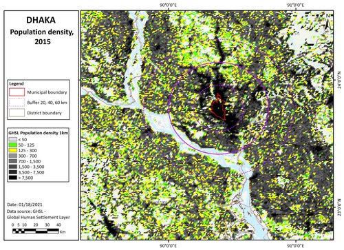
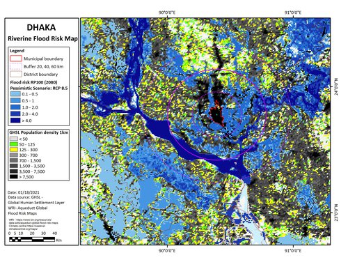
Population density map
This shows three population density bands: 0-50, 50-125, and 125-300 persons/km2: (transparent for open land, and then green and yellow cells). These are in different proximities to the main urban centres, for the moment defined by distances (from the urban centre), of 0-20, 20-40, and 40-60km: titled 'near-urban', 'near-urban: further urban: and ex-urban / peri-rural'.
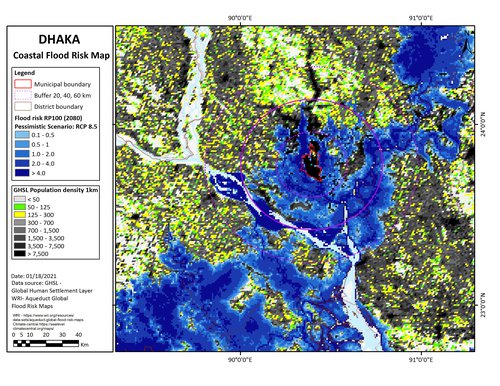
Climate projections: coastal flooding
Including sea level rise, tidal, and storm surge effects, this is a 'reasonable worst case scenario' for 2080, with reduced policy and pessimistic modelling. This is based on the mapping from www.climate-central.org
Climate projections: river flooding
This is a 'reasonable worst case scenario' for 2080, with reduced policy and pessimistic modelling. This is based on the mapping from www.climate-central.org
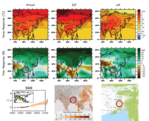
Climate projections: temperature effects
Top six images show annual, summer, and winter temperature, and precipitation changes. Bottom left shows projected temperature changes for a range of scenarios by 2100. Centre bottom shows daily temperature events within the top 0.1% recorded local temperatures from 1979 to 2017. Bottom right shows the 2010 forest cover.
Sources:
IPCC-WG1 2016
NOAA
Global Forest Watch