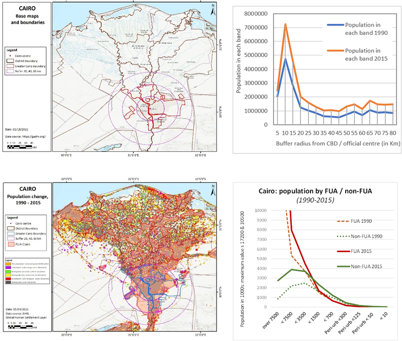
Spatial issues
Urban areas: very rapid growth in high density & some medium density.
Non-urban areas: steady growth in medium density.
- Urban areas of Cairo had been expanding extensively to the north towards the coastal areas where farmlands are the predominant social and economic activities. In these areas there are several satellite cities of medium to high density.
- In recent times Cairo’s urban areas are expanding towards the east and west in a form of scattered and sporadic urban development. In these areas there are construction of several high-class residential areas, mainly within the 20-40 km buffer zone.
- Some of the scattered urban expansion were informal. Agricultural lands are being converted through construction without planning permission.
- Multinational companies settle around the Suez Canal economic zone, which triggers growth alongside the highway connecting the Cairo urban centres to the canal. This regional corridor density seems to be increasing with more newly built high-class residential areas. This development coincides with the emerging growth of economic activities in Ramadan City, situated between Cairo and the Suez Canal.
Climate change issues
- A dominant type of the peri-urban areas (unplanned new urban communities) in the Greater Cairo Region (GCR), is mainly located around the ring road, this is illegal expansion of the core city, and encroaches on agricultural lands.
- These structures are highly exposed to a high level of pollution because of the roads’ proximity and the high capacity of motorized vehicles
- In addition, the compact urban form with low permeability may suffer from UHI effect
- The expansion of the peri-urban areas on the agricultural lands causes agricultural lands removal and land cover changing, which may lead to food insecurity among other challenges.
- In addition to water shortages, the city, especially its per-urban areas and new urban communities are challenged by urban flooding, these dangers are intensified by increased urbanization around the city that limits where floodwaters can flow.
- These extreme weather conditions, that are expected to grow due to climate change and water systems in cities in the global south are often unable to cope with these challenges, bringing cities to halt and damages and losses in millions (WEF, 2011).
- In the past years, Egypt has been witnessing increase in rainfalls and flooding in the winter seasons that caused houses collapse, power outages and chaotic traffic conditions (Egyptian Streets, 2020).
- The majority of climate mitigation funding is dedicated to low coastal development so far: very little funding goes to addressing climate change impacts in agricultural lands in the delta or protecting the vulnerable communities of informal areas in the urban and peri-urban areas (O’Connell, 2021), (Charbel, 2017).
Societal issues
- Some of the Peri-urban areas suffer from the inappropriate urban structure (physical vulnerability). Buildings suffer from inadequate spaces for living or inappropriate orientation for ventilation. On the other hand, there are buildings with well-constructed concrete structure.
- Infrastructure provision of the peri-urban areas in terms of electricity, water, sewage....etc. mainly depends on illegal connections to the public networks or depending on off-grid sources.
- Some development plans of the peri-urban areas depends on international grants such as GIZ grant for developing the informal areas in Egypt and initiatives of the NGOs.
- The governmental act in these areas is represented in granting legal ownership rights to residents of these areas and legalizing their status and their benefit from the infrastructure.
Governance issues
- Public land management: land owned and controlled by the government forms around 90% of the country’s surface area. Managing this resource in ways that benefit the country’s economy and the mass of its people is crucial.
- Challenges related to public land management: There is almost no publicly available public land information system or inventory, resulting in confusion for both investors and citizens alike on which institutions control what land, where it is available, and under what conditions.
- There is limited monitoring of development projects ‘feedback loops’, once lands have been allocated to find out what has worked and what hasn’t and why. The various authorities that allocate public land, such as NUCA, GARPAD, and TDA, but rarely carry out evaluations or lessons-learned exercises.
- The need for a coherent national policy that defines the purposes of the public land asset and how to deal with it is yet to be met, individual self-serving decisions about public land are common. The actual figures show how little public land has managed to directly benefit the masses. (Sims, 2015). The Peri-cene takes a practical approach to the complexity of peri-urban-climate interactions. The base-maps here build on the JRC-GHSL (Global Human Settlements Layer) system of urban mapping with 1 km2 cells http://ghsl.jrc.ec.europa.eu . In this way the peri-urban definition and mapping is not a final answer, but the start of the discussion.