Peri-urban issues
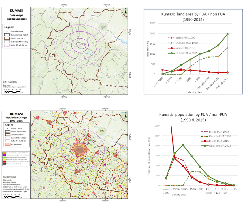
Summary of spatial analysis:
- Urban areas: sudden growth in higher density population, falling off to the urban edge:
- Non-urban areas: inner peri-urban areas show rapid growth in medium densities:
- hinterland shows a steady land area growth, & outward spread of population along the urban-rural gradient.
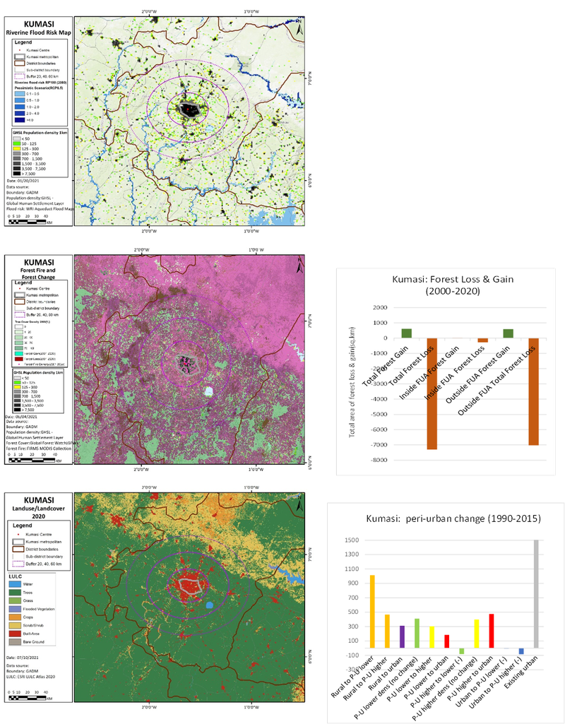
Built & developed as a concentric ‘Garden city’, radiated by 5 main corridors, connecting Kumasi to Ghana. Peri-urban devolvement occurs along the major corridors: led by individuality, local and traditional land management combined with planning agencies. Peri-urban change map shows rapid conversion of rural to peri-urban in SE areas.
Small communities live around the cities, farming communities (subsistence). The subsistence farmers cannot afford to buy their land, the tribal leaders can sell it off. Even if land is ‘bought’ by those living on the land, it is leased for 99 years. With rapid urbanisation the traditional leaders just take the land back.
Middle income families are pushing subsistence farmers out of their land. Some farmers are changing livelihoods to construction. Peri-urban areas are growing mainly by middle class encroachment, under a dual ‘customary’ legal system, displacing the land and livelihoods of many indigenes.
Climate change issues
- Temperature projections to 2100 – 2-7+ degrees rise:
- Precipitation: DJF 30% uplift, with growing storm conditions.
- Extreme wet heat days of 35+ degrees could double or more
- All existing river systems are set to flood in rainy season.
- Forestry loss in most of hinterland, many forest wildfires in NE sector. Farming under pressure from new economic models, urbanizing cultures / lifestyles.
- Landuse change is impacting on ecosystems & carbon balance: water balance is fragile for subsistence farmers.
- Farming and former national parks are being encroached. Most of the wetlands and rivers are drying out, this is changing the ability for farmers to farm and so they must diversify their livelihood or relocate.
Agriculture
Cassava, Yam, Cocoyam, Cocoa.
Vulnerability cause
Unreliable/unpredictable rainfall, deforestation, degraded soils, drought, low income source, production rate drop due to temperature increase. aging population of farmers, spatial decline of available growth areas
Adaptation measures
Introduce varieties with different maturity periods, introduce drought resistant varieties, integrate nutrient management into cropping, afforest degraded forest land, generate alternative income sources, change irrigation to under root.
Adaptation programmes
RTIMP, WAPP, CARE International.
Climate change and health
Malaria, Diarrhoea, Guinea worm, cerebral spinal meningitis, measles.
Vulnerability cause
Measles cases will increase by 2080 due to increased air temp, and reduced rainfall (although currently decreasing). Gradual rise of incidence of meningitis cases over range of months where cases are typically high. Diarrhoea increase risk due to reduced rainfall and increased mean air temp.
Adaptation measures
Breaking transmission cycle, destroying mosquito and cyclops breeding sites. Management of cases. Reduce cyclops host contact through provision of safe water, filtration of water, searching for active cases to avoid water contact. Ensuring infected persons avoid contact with ponds. Chemical destruction of crustaceans, vaccination of high risk groups, increased vaccine campaigns. Improving housing and ventilation. Improving case management and education.
Adaptation programmes
UNDP climate change and health project, Climate change and health in coastal community in Accra Project (RIPS).
Societal & governance issues
Unreliable rainfall patterns with heavy reliance. Inadequate irrigable lands. Harvest failures from improper adaptive strategies. Reduced biological productivity. Progressive loss of non-timber forest products. Increased land degradation, loss of arable land.
Reduction in livestock size and nutrition. Industry disruption possibly due to energy sector crisis. Raw material supply chain disruption. Higher risk property insurance. Population displacement.
Informal settlements are moved but without a clear location, so residents move back towards the centre, which then is unattractive to the middle classes, who then seek new peri-urban locations. Westernisation of the middle class is changing the housing preferences from compound housing to nuclear family living, greater peri-urbanisation.