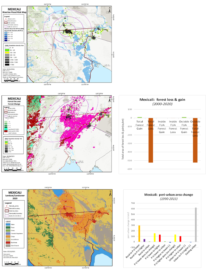
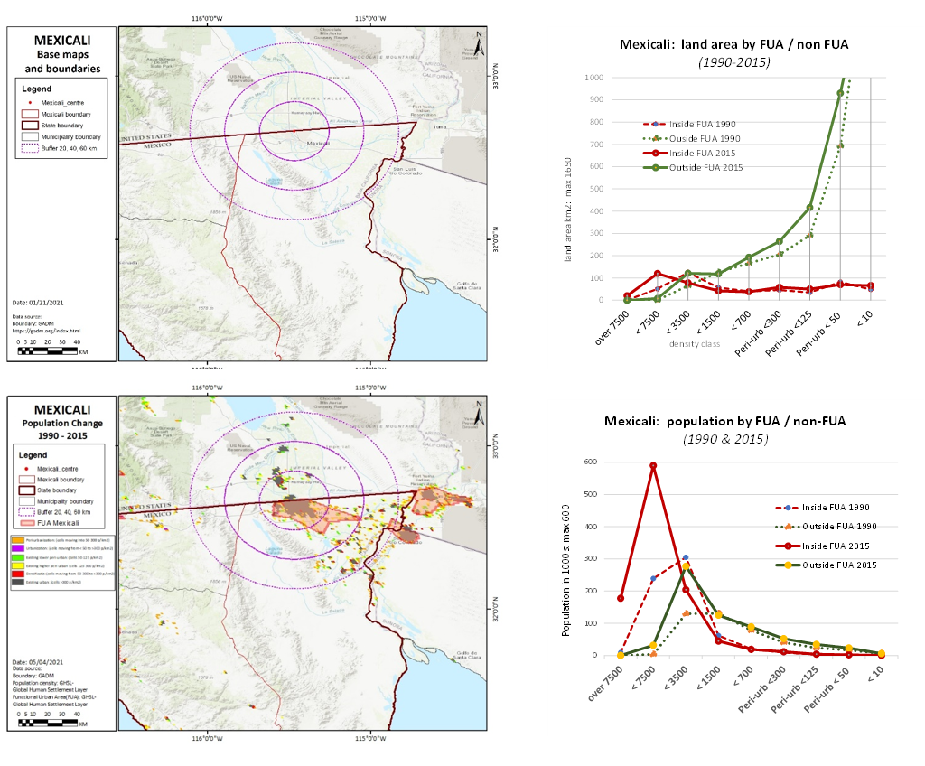
Mexicali lies on the US-Mexico border with a dynamic growth of urban areas expanding towards the south and east. The outward spread of low-density development has caused the declining population density at the urban centres. Population are distributed to the east (for high-class peri-urban dwellers) and south / south east (middle-class dwellers). Meanwhile, the Laguna Salada, a mountainous area surrounded by agricultural lands, serve as a constraint for urban expansion towards the west / southwest.
Besides housing, industrial development is also an emerging sector of the peri-urban
The urban to peri-urban migration is caused mainly by the provision of housing that is spatially distributed towards the east and southeast peri-urban. In recent years, this migration has become more significant.
Developers play a key role in developing an expanding structure of urban and regional development. Developers gain profit in the peri-urban property business by purchasing lands at lower prices and selling them at significantly higher prices. These developers have strong connection with authorities which they attempt to influence the direction of land use policies to accommodate the growth of residential development.
A structure of bioregional south – reservoir, river basin and geothermal power plant at the south
Peri-urban transformation: Abandoned low-class peri-urban residential areas are transforming to middle-upper class. At first, the low-class residential areas were part of the public housing agenda, which is to provide affordable housing for the low-income communities. In later development, the value of the area declined due to vandalism and rising crime. This have attracted developers to acquire these areas and rebuilt them to apartments, condominium and other middle-upper housing supplies.
The remaining low-class residential areas are gradually declining. Most of these settlements do not have sufficient infrastructure services and are in high risk of crime which is exacerbated by the lack of facilities like police stations.
For agriculture, most of the lands were owned by the states (before 1990). After 1990, the state granted private ownership status of these farming parcels. But as the value declines, labour farmers refused to return to faming. This subsequently caused further decline of agriculture. From this stage, landowners sell or rent their lands to private developers, which later being converted to residential, industrial and commercial activities
This goes with the US-Mexican border and the interrelation of water resources influencing both sides. The agricultural lands in Mexicali’s peri-urban areas rely on water supply that flows from the US. In general, Mexicali has extreme vulnerability of water supply. This is exacerbated by the government who is continuously encouraging FDI to invest more without appropriate measures of how to supply these industrial activities, let alone the construction process.
Climate effects
Temperature effects – 3 °C average temperature increase (A2 scenario – increased population, heterogeneous development), extreme max temperature increase of +9 °C in July by 2050.
Extreme weather – Reported in between 2000 - and 2010 there were 2.3 times as many heatwaves compared to 1970 – 1980. Heat associated deaths – As heatwaves increase, deaths associated with heat, “heatstroke”, will increase.
Total Annual Rainfall has increased in the Mexicali region (1922 – 2004)
ENSO (El Niño Southern Oscillation) extremes likely to increase, resulting in drier climate during La Niña years, and wetter La Niño years.
Water – 57% comes from the Colorado River, 37% comes from underground sources, 10% comes from coastal aquifers.
As there is no current capacity to store rainwater the future La Niña years may be problematic for Mexicali. There will be increased water consumption across the USA-Mexico border from the Colorado river, water scarcity may increase in Mexicali.
Water consumption by farming in the Mexicali Valley uses more water than is provided by the Colorado river. If underground sources are not recharged a water crisis in the Mexicali Valley will occur.
Urban heat island – greater urbanisation and migration to urban areas results in higher exposure to extreme heat. An additional maximum intensity effect of 5.2 °C in the summer time further increases the impact of extreme heat in the region.
Urbanisation and transport emissions - By 2025 transportation will account for 44% of the state emissions. 84% of daily trips are private cars, 68% of Mexicali air pollution is from transport, continued urbanisation may result in increased private car use, increasing city emissions, and worsening air quality. This growth and use of private vehicles may be a result of removing taxes and mandatory insurance.
Societal & governance effects
Unregulated use of pesticides and fertilizers in agriculture, alongside water overuse have effects on the local flora and fauna.
Use of recycled water is at 80% in the Mexicali valley, this improves resilience to water shortages.
Predicted population increases in urban areas of Baja California will be concentrated in border cities; Mexican urban centres are likely to increase from 44.6% of the population (2005) to 58.1% by 2030.
Farming vulnerability - water use changes upstream in the Colorado river will directly impact the availability of water in the Baja California area.
Diversifying crop portfolios with low water consumption crops increases farmers resilience to water shortages. Investing in drip watering systems may improve irrigation and reduce water loss. Cement lining canals is also a consideration to improve water transportation to farm sites, cement lining however reduces the recharge ability of groundwater sources, potentially delaying but increasing the impact of a future water crisis.
State Climate Action Plan – 3 HE institutions, 2 federal authorities, binational environ cooperation: they identified over 100 actions in mitigation and adaptation to climate change.
there is a strong coalition between private developers with authorities. Through this political relation, developers were able to influence the land use policy, which became a factor to the rapid growth of peri-urban areas
The government is transforming from an agent for people (e.g. through public housing agenda) to an agent who advantages from the profit of property markets.