Peri-urban issues
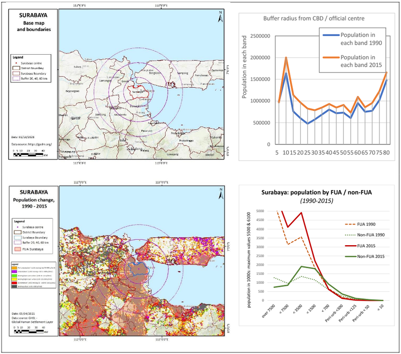
Spatial analysis (from the charts overleaf):
- Within the urban area, the historic city is very high density (>7500): the population in the extended city area is then medium-high density (3000-7500), with a steady increase, which drops off at the edges
- Outside the urban area most population is at medium of 700-3500 p/km2, with a rapid near doubling over 25 years.
Surabaya Metropolitan Area is the second largest urban agglomeration after Greater Jakarta and the most rapidly growing urban region in Indonesia (by urban population size). In general, sprawl of large-scale residential enclaves surrounded by small housing clusters. Infilling urban development (housing, big and local retails) beyond the inner-city area. Formation of contiguous urban areas between neighbouring regencies (Gresik at the north-west and Sidoarjo at the south).
- Sprawl of large-scale residential enclaves surrounded by small housing clusters. Infilling urban development beyond the inner-city area. Peri-urban expansion along river basin to SW, overlaid on paddy field patterns. Major industrial areas to NW & SE
- Growing middle class & rapid transition from rural society to industrial & urban. Over-pricing of city, preference for peri-urban, property investment motives (some residential areas have low occupancy rate).
- Surabaya as capital city in main province, means large commuting & in-migration. CBD is shifting to orbital route locations, W&E are becoming industrial, stable growth in north and south. Suramadu bridge connects Surabaya & Madura Island.

Climate change issues
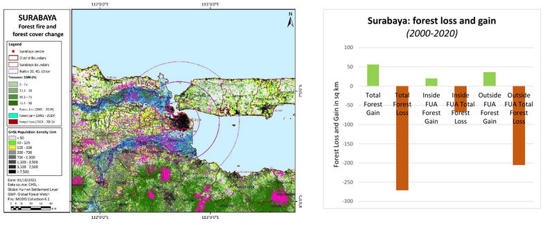
Climate & environment: increased flood vulnerability, & Urban Heat Island effect is increasing. UHI tends to decrease as more public paths are being developed, UHI in central Surabaya is lowering. In east and west UHI is low, due to area dominated by palm and mangrove. North and east development is overlapping with sea level rise areas. River pollution and acid rain.
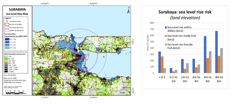
- Precipitation projections: summer large rise, winter rapid fall. Temperature projection of 2-6 degrees by 2100: Sea level rise N&E: rapid development of urban enclaves overlapping areas below sea level.
- Growing flood vulnerability & UHI effect. UHI is lower in E&W areas, due to palm & mangrove. North and east development is overlapping with sea level rise areas. River pollution and acid rain.
- Acidic rain from industrial gas emission flows into water bodies - soil & water contamination - effect on agriculture, public health, quality of drinking water
- High mobilization, dynamic area development, fast population growth requires massive flows of energy, food, water and other goods.
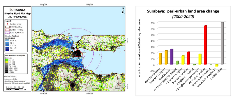
Climate projections: river flooding
Including river flooding and related extreme events, this is a ‘reasonable worst case scenario’ for 2080, with reduced policy and pessimistic modelling. This is based on the mapping from https://www.wri.org/resources/maps/aqueduct-global-flood-analyzer

Climate projections: coastal flooding
Including sea level rise, tidal, and storm surge effects, this is a 'reasonable worst case scenario' for 2080, with reduced policy and pessimistic modelling. This is based on the mapping from www.climate-central.org


Societal issues
- family land ownership is small ~1/4 Ha: government policy for each family to have 2 Ha. In Surabaya the pastures could be held by one company or person, local small-scale workers don’t own land. Farming in Surabaya is mainly hand managed (non-industrialised), with good maintenance of soils.
- peri-urban expansion to S& W overtakes the infrastructure, with long commutes to industrial jobs. Peri-urban communities are polarized - with affluent professional / former rural now industrial workers.
- Vulnerability decrease & sensitivity increases - higher resiliency: New suburbs & ex-urbs may lack social cohesion & capital.
- Community participation towards adaptive actions with environmental movement (e.g. mangrove plantation). Government initiatives to foster community – private (associations & industries) – academics (e.g. CSR for public parks, river normalization, biophilia, bio pore)
Governance issues
- 2007 spatial planning act recognises the role of local government: practice of planning has improved & more actors are (formally) involved (e.g. developers, local people): but questions on ‘real engagement’.
- Some governments have advanced digital systems. For water policy government took a top down management view: more recently locals are involved in communications & outreach on waste management & pollution.
- Indonesian Corruption Watch (National – Local Level); WALHI – environmental issues; Indonesian Green Peace: Informal process of land acquisition and planning permission. High level local authority and private sector coalition (the elites) and political interests and goals
- Social resiliency seems stable + high adaptive capacity; economic resiliency fluctuated – macro level is quite vulnerable, micro level (community level) is quite stable, impact of COVID-19 is significant for informal sectors (UMKM – micro/small enterprises).
