Bangkok region: location
Bangkok region
(The map here shows circles of 20, 40 & 60km radius, a rough approximation to the gravity field).
Bangkok region: overview
Historic primate city, major port and economic powerhouse of Thailand. Bangkok's rapid growth coupled with little urban planning has resulted in a haphazard cityscape and inadequate
infrastructure. An inadequate road network with substantial private car usage,
have led to chronic and crippling traffic congestion and severe air pollution.
Peri-urban development is led by corporate real estate with many forms of suburban and
ex-urban development, displacing water-intensive cultivation.
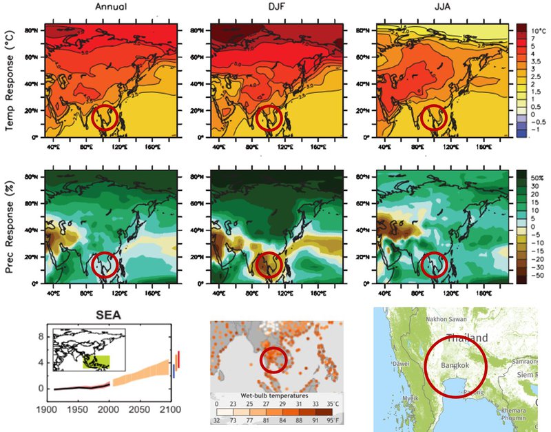
Climate-environment prospects on a tropical savannah coastal location: high risk of extreme heat
and wildfire, coastal flooding and cyclone with other forms of flooding also
likely.
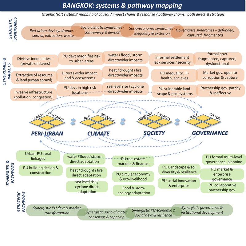
Bangkok is a rapidly expanding megacity, with intensive disruption of water systems & ecosystems, in a highly climate challenged location, struggling with divided governance systems.
Peri-urban syndromes: rapid urban & industrial sprawl into low-lying landscape with complex water systems: disruption of ecosystems & rural livelihoods: development in high risk locations:
Climate change syndromes: riverine flood, storms, landslides: sea level rise & incursion: upstream forest depletion, disruption to soil & ecosystems & water systems, displacement of floodwater to urban areas: urban heat island & air pollution: increasing extreme wet heat days:
Societal vulnerability: social change & gentrification: suburban expansion & exclusion: disruption to livelihoods & farming:
Governance syndromes: widespread political instability & fragmentation, materialist priorities, elite capture, illegal construction & encroachment: climate awareness & climate policies hardly exist:
Adaptive pathways: urban-rural linkages for food & ecosystems, distributed work & local livelihoods: integrated water management & multi-functional landscape resilience: climate-wise peri-urban design & infrastructure:
Adaptive governance: strategic integrated climate-wise planning: civil society governance structures: socio-climatic integration of all policies.
Bangkok region: where is the peri-urban?
Scope: the Bangkok metropolitan region is clearly defined within the 200km frame here. However the upstream water catchments and bio-regions are on a larger scale.
- Agriculture remains a significant sector for local economy and a contributor to the national GDP. As one of the biggest agricultural nations, Thailand had big agenda to develop their agricultural sector. Since 1700s and proceeding in the past 100 years, Thailand has been extending the irrigation network to maintain productivity of the farming parcels. As a result, many of the agricultural lands within the peri-urban areas are prime and highly productive until recently.
- Rural-urban transformation take place by first by the abandonment of agricultural lands by cutting them of form the irrigation canal. Usually industrial development follows this phase before residential areas are constructed in the following stages. In social-economic terms, there are transformation of jobs from farming to manufacturing industries. Following the agricultural land takes, the construction of manufactures or real estate is usually followed by further damage of the irrigation system. This cause a growing number of abandoned agricultural lands and hence attracted further land takes.
- Land morphology is a factor determining land conversion. Land that are too narrow are usually less attractive particularly to the residential sector. This is apparent in lands obtained from individual farmers, hence are converted slower than elsewhere.
- Part of the peri-urban settlements are informal with poor infrastructure and public services. These settlements usually occur alongside the river/irrigation canal. In these particular areas, the canal also accommodates transport (water taxis) for local mobilisation. Being located alongside the canal means that these informal housing is inhabited on public lands. Another reason for the use of canal transportation is the conflict between new Vs pre-existing residential areas. Most of the pre-existed informal settlements are bypassed of access due to constriction of real estates.
- There is also significant growth of high-rise apartments within the peri-urban, mainly designated for industrial workers. Some of these apartments did not come with sufficient infrastructure and public services.
- With the decline of green open spaces, and destruction of irrigation canal (which also functions as flood regulator) some areas in the peri-urban are prone to flooding. The recent major flood disaster in the north peri-urban triggered temporary out-migration, but now people have returned to inhabit the peri-urban.
Bangkok region: system mapping
Bangkok region: summary data
Climate hazard
(World Bank data profile for Bangkok)
Extreme heat - High
Wildfire - High
Water scarcity - Medium
River flood - Medium
Urban flood - Medium
Coastal flood - High
Cyclone - High
Tsunami - No data
Landslide - Very low
Earthquake - Low
Volcano - No data
Spatial mapping
The Peri-cene takes a practical approach to the complexity of peri-urban-climate interactions. The base-maps here build on the JRC-GHSL (Global Human Settlements Layer) system of urban mapping with 1 km2 cells http://ghsl.jrc.ec.europa.eu . In this way the peri-urban definition and mapping is not a final answer, but the start of the discussion. For more on the questions of 'where is the peri-urban?' and 'how is it changing?' download the D3-1 report.
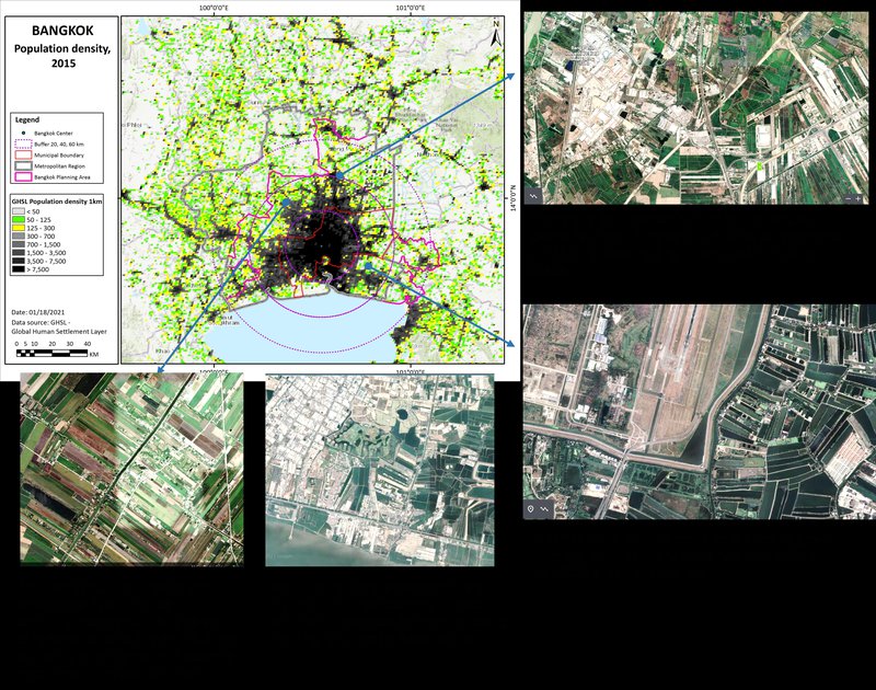
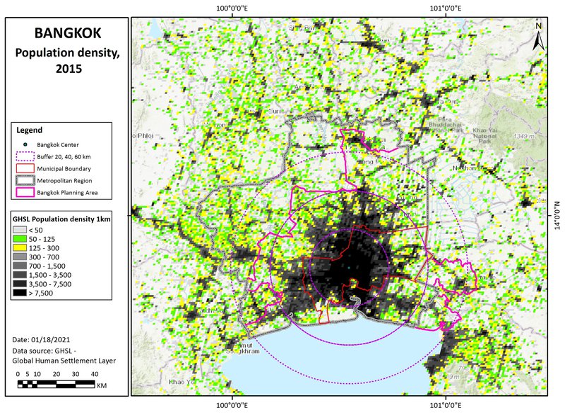
Population density map
This shows three population density bands: 0-50, 50-125, and 125-300 persons/km2: (transparent for open land, and then green and yellow cells). These are in different proximities to the main urban centres, for the moment defined by distances (from the urban centre), of 0-20, 20-40, and 40-60km: titled 'near-urban', 'near-urban: further urban: and ex-urban / peri-rural'.
Population change map
Content coming soon.
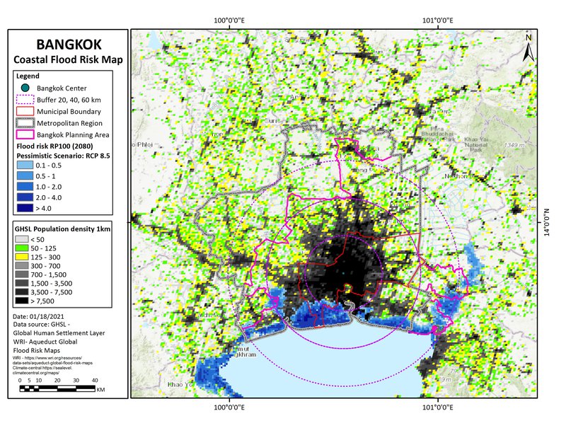
Climate projections: coastal flooding
Including sea level rise, tidal, and storm surge effects, this is a 'reasonable worst case scenario' for 2080, with reduced policy and pessimistic modelling. This is based on the mapping from www.climate-central.org
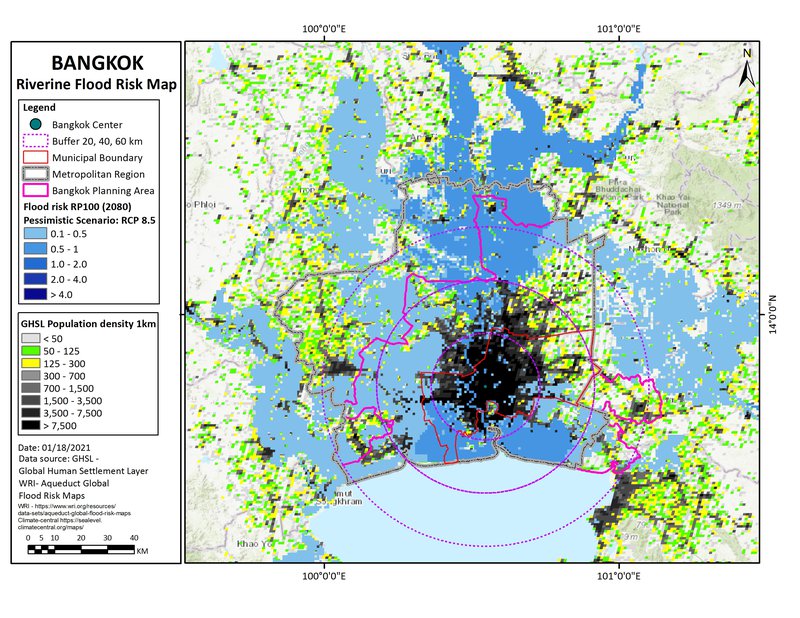
Climate projections: river flooding
This is a 'reasonable worst case scenario' for 2080, with reduced policy and pessimistic modelling. This is based on the mapping from www.climate-central.org
Climate projections: temperature effects
Top six images show annual, summer, and winter temperature, and precipitation changes. Bottom left shows projected temperature changes for a range of scenarios by 2100. Centre bottom shows daily temperature events within the top 0.1% recorded local temperatures from 1979 to 2017. Bottom right shows the 2010 forest cover.