Peri-urban issues
Spatial analysis (from the charts overleaf)
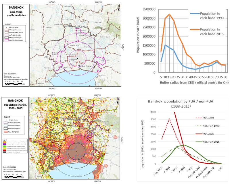
- Within the urban areas, very high / high density populations have more than tripled:
- Outside the urban areas, populations at medium urban and peri-urban densities have doubled.
- Rapid urbanization of formerly rural areas with industrial & residential development. A complex interaction of new urban development overlaid on existing field patterns, canal & paddy farming systems. Urban expansion to the W more intense with agricultural land takes by urban development. To the N & E peri-urban is mainly in agriculture (prime irrigated parcels) but with growing urban pressure.
- Peri-urban development is led by corporate real estate with many forms of suburban and ex-urban development, displacing water-intensive cultivation. The water system & rural field pattern is the main shaper of the urban form. Even with rapid expansion, growing housing shortage & land price inflation.
- Many developers buy up farming land, some with international finance. The coup made further complications in government & financial systems.
- Rural-urban transformation take place by first by the abandonment of agricultural lands by cutting them of form the irrigation canal. Usually industrial development follows this phase before residential areas are constructed in the following stages. In social-economic terms, there are transformation of jobs from farming to manufacturing industries. Following the agricultural land takes, the construction of manufactures or real estate is usually followed by further damage of the irrigation system. This cause a growing number of abandoned agricultural lands and hence attracted further land takes.
Climate change issues
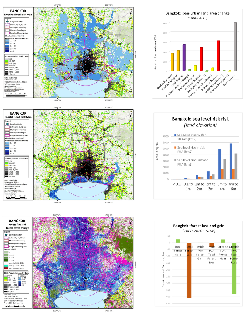
- Precipitation: summer slow increase is projected: winter major reduction. Temperature rise projection of 1.8 –5.5 degrees by 2100
- Sea level rise – _much of coast area is below 2m: most of region 2-4m above sea level. Climate-environment prospects on a tropical savanna h coastal location: high risk of extreme heat & wildfire, coastal flooding & cyclone.
- Droughts, coastal and riverine floods (Chao Phraya River). Bangkok is on average 1m above sea level, and currently sinking due to over consumption of groundwater, combined with sea level rise the risk of coastal flooding increases faster than other coastal areas of Thailand
- Sea level rise causing salination of farmland: lack of tree cover & biodiversity in the city-region.
- chronic traffic congestion and severe air pollution. Urban heat island - temp increase of 13 °C. International airport was located on agricultural land reducing water drainage services: illegal construction obstructs drainage efficiency, increasing flood severity.
- Strained healthcare infrastructure in response to flood borne diseases. Farming industry affected by flooding. Thailand is the world’s largest rice exporter, 40% of the population rely on agriculture for employment. Tropical storms, and droughts are likely to affect future rice yields. Livestock farming may be at risk due to heat stress, and disease outbreaks.
- Urban heat island in Bangkok looks to have an increase effect of 13 °C. International airport was located on agricultural land reducing water drainage services, this may increase future flood intensity. Illegal construction obstructs drainage efficiency, increasing flood severity
Societal issues
- As the world’s largest rice exporter, 40% of Thai population rely on agriculture for employment. Tropical storms, and droughts are likely to affect future rice yields. Livestock farming may be at risk due to heat stress, and disease outbreaks. Freshwater fish populations affected during drought periods.
- Heat stress and water borne diseases are likely to increase such as dengue fever. Weather related air pollution will continue to increase as temperature and humidity increase. Summer heatwaves will affect health labour productivity and increase urban energy consumption. Increased global migration by 2050, Bangkok predicted to receive large numbers of migrants. Bleaching corals may reduce tourism to the area, having negative economic consequences
- With the decline of green open spaces, and destruction of irrigation canal (which also functions as flood regulator) some areas in the peri-urban are prone to flooding. The recent major flood disaster in the north peri-urban triggered temporary out-migration, but now people have returned to inhabit the peri-urban.
Governance issues
- Land use planning is ineffective, vested interests shape plans. Recent attempt to transfer authority for spatial planning national to local level. Private sector have already acquired many of the peri-urban lands before land use policy was constructed. Local governments favour ‘hard’ water management & flood defence
- Environmental grassroot movements of farmers, reconstructing natural water system to mitigate flooding while maintaining supply for crops. But when private sectors approach to purchase their lands at higher prices, they release them & move to another job in the industrial sectors
- lack of environmental law enforcement, and lack of climate change response framework. Corruption in political systems, and low institutional capacity to consult, and manage real commitments. In the past budgets have been diverted to crony projects, infrastructure investment has suffered.
- Governance is contested between a centralizing state, under-resourced local authorities, some civic groups & some farmers groups.