Peri-urban issues
Toronto is situated in the ‘golden horse shoe’ area, a region where approximately 25% of Canada’s population live. Toronto’s urban areas continues to expand, mainly to the west and north of the region. Urban expansion is also prominent in the city of Hamilton where the request to extend the municipal boundary is now being negotiated over the potentiality of expanding to the green protected areas.
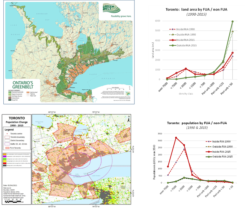
- Toronto’s peri-urban areas consist of the green belt (which predominates the northern peri-urban) and the “white belt” zone, which situated in between the built-up areas and the green belt. (see map below)
- The green belt is the ‘protected countryside’ where urban development, especially on agricultural lands, is highly restricted. The only acceptable urban development is alongside the main roads forming a linear urban spatial structure. Meanwhile, the ‘white belts’ (zones in between the urban built up and the green belt) are zones already under negotiation to be transformed into urban areas. Most of the lands within these zones are likely to be owned already by private companies or individuals who are not farmers.
- Toronto targeted their urban population to be around 50 million in 2040. This projection considers the growth and further potential increase of international in-migration.
- With the growth of population and potential in-migration, Toronto’s housing market prices have tripled in the last 10 years, hence there will be more people preferring to live in the peri-urban rather than the CBD
- Some problems/issues with regards to peri-urbanisation - Inequality in terms of infrastructure services (e.g. more highways are being constructed but none of them are useful for the low-income people), commuting time as more people reside in peri-urban areas, unequal distribution of public services (e.g. insufficient schools in low income neighbourhoods). There is also a trend of peri-urban hollowing in the city of Oshawa due to the declining activities in the car manufacturing industry.
- There are also dynamic changes in the farming sectors – Consolidation of a number of small and medium farm sites. Some of the farm houses are being converted to single family homes
Climate impacts
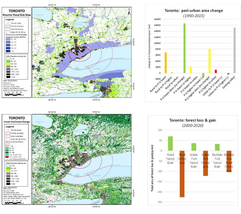
- Heavy downpours may result in combined sewer overflows, damaged infrastructure, erosion of stream and rive banks, and flushing of pollutants into waterways. Hydroelectric production will be affected by drop in lake water levels. Nuclear and coal generating stations efficiency will decrease due to reduced efficiency of condensers. Summer energy demand increased, greater electrical energy strain may lead to brownouts or blackouts. Transport may be affected by blackouts due to traffic light outage. Shipping activity at the Port of Toronto will face significant costs if water levels in the Great Lakes Basin drops, ships will have to reduce loads to navigate shallower channels. Flights may be affected more due to increased incidence of extreme weather events. Storm damage to buildings is likely to increase. Milder winters have brought more freeze-thaw cycles leading to greater building material wear, increases in extreme weather events will damage infrastructure.
- Increased urban development that does not mitigate for increased rainfall intensity through flood mitigation will increase the flood risk in the city of Toronto due to decreased surface permeability leading to more surface flooding. Though compared to other major Canadian cities climate change will be the dominant effect of flooding as development in Toronto has maintained some green and blue infrastructure to combat flooding.
- Greater urbanisation will increase the urban heat island effect, putting greater pressure on residents health during times of extreme heat.
Governance issues
- Land use planning is conducted at municipal levels, while areas of strategic development which involve cross-boundary partnership is guided by the provincial development planning.
- While the framework promotes inclusive planning, there is a gap of knowledge particularly in formulating the green belt policy – local people and farmers have insufficient knowledge on policies regulating the green belt.
- There is an emerging framework for environmental planning. For instance, the clean air partnership which focuses on promoting sustainable cities. However, protecting the green belt does not seem to be the main agenda of this framework.
- There is obvious donation from political party, but nothing is known about corruption
- There is a long history of mafia that links to construction industries. (Anecdote: they drive to people’s houses to make decisions).
- The minister who is responsible for the spatial plan could change the direction of plan if the is an agreement from the majority of people.